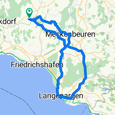
TOUR-Magazin "Argental"
A cycling route starting in Oberteuringen, Baden-Wurttemberg, Germany.
Overview
About this route
- -:--
- Duration
- 63.7 km
- Distance
- 775 m
- Ascent
- 792 m
- Descent
- ---
- Avg. speed
- 594 m
- Max. altitude
Route quality
Waytypes & surfaces along the route
Waytypes
Quiet road
21 km
(33 %)
Road
19.1 km
(30 %)
Surfaces
Paved
58 km
(91 %)
Unpaved
1.3 km
(2 %)
Asphalt
58 km
(91 %)
Gravel
0.6 km
(1 %)
Continue with Bikemap
Use, edit, or download this cycling route
You would like to ride TOUR-Magazin "Argental" or customize it for your own trip? Here is what you can do with this Bikemap route:
Free features
- Save this route as favorite or in collections
- Copy & plan your own version of this route
- Sync your route with Garmin or Wahoo
Premium features
Free trial for 3 days, or one-time payment. More about Bikemap Premium.
- Navigate this route on iOS & Android
- Export a GPX / KML file of this route
- Create your custom printout (try it for free)
- Download this route for offline navigation
Discover more Premium features.
Get Bikemap PremiumFrom our community
Other popular routes starting in Oberteuringen
- TOUR-Magazin "Argental"
- Distance
- 63.7 km
- Ascent
- 775 m
- Descent
- 792 m
- Location
- Oberteuringen, Baden-Wurttemberg, Germany
- Bodenseerunde
- Distance
- 255.7 km
- Ascent
- 396 m
- Descent
- 396 m
- Location
- Oberteuringen, Baden-Wurttemberg, Germany
- Hopfenrunde Taldorf
- Distance
- 59.9 km
- Ascent
- 354 m
- Descent
- 358 m
- Location
- Oberteuringen, Baden-Wurttemberg, Germany
- Joggingstrecke 1 Bitzenhofen
- Distance
- 9.2 km
- Ascent
- 262 m
- Descent
- 259 m
- Location
- Oberteuringen, Baden-Wurttemberg, Germany
- Zum Hackl Schorsch
- Distance
- 21.3 km
- Ascent
- 453 m
- Descent
- 208 m
- Location
- Oberteuringen, Baden-Wurttemberg, Germany
- Ailingen Bodnegg
- Distance
- 47.2 km
- Ascent
- 374 m
- Descent
- 378 m
- Location
- Oberteuringen, Baden-Wurttemberg, Germany
- TOUR-Magazin "Allgäu"
- Distance
- 77.5 km
- Ascent
- 896 m
- Descent
- 904 m
- Location
- Oberteuringen, Baden-Wurttemberg, Germany
- OT Langenargen
- Distance
- 49.1 km
- Ascent
- 175 m
- Descent
- 178 m
- Location
- Oberteuringen, Baden-Wurttemberg, Germany
Open it in the app