

Around my Rockies 2009
A cycling route starting in Chestermere, Alberta, Canada.
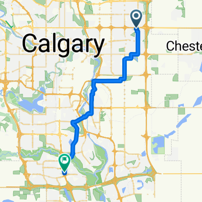
Overview
About this route
Three years ago I tried to bike around the southern range of 'my Rockies' (the closest part to Calgary, those peaks that you can see from Calgary). It did not work. So here is my second attempt on the same route. Successful this time. I biked almost exactly 800km in 6 days. With the Pure Beauty around me: Calgary - Crowsnest Pass - Sparwood - Fernie - Fort Steele - Invermere - Radium Hot Springs - Banff - Canmore - Calgary. I enjoyed every meter of this trip. And I will NEVER forget the thumb up someone gave me thru the window of a passing car when I was down, cholering and bitching on a rain and a head wind and a 150+ km day...
- -:--
- Duration
- 814.1 km
- Distance
- 2,055 m
- Ascent
- 2,055 m
- Descent
- ---
- Avg. speed
- ---
- Max. altitude

Route highlights
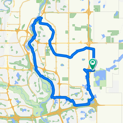
Points of interest along the route
Point of interest after 131.3 km
Day 1 - END, tenting
Point of interest after 269.1 km
Day 2 - END, tenting
Point of interest after 424.1 km
Day 3 - motel
Point of interest after 532.5 km
Day 4 - tenting at rest area
Point of interest after 651.8 km
Day 5 - campground, tent
Continue with Bikemap
Use, edit, or download this cycling route
You would like to ride Around my Rockies 2009 or customize it for your own trip? Here is what you can do with this Bikemap route:
Free features
- Save this route as favorite or in collections
- Copy & plan your own version of this route
- Split it into stages to create a multi-day tour
- Sync your route with Garmin or Wahoo
Premium features
Free trial for 3 days, or one-time payment. More about Bikemap Premium.
- Navigate this route on iOS & Android
- Export a GPX / KML file of this route
- Create your custom printout (try it for free)
- Download this route for offline navigation
Discover more Premium features.
Get Bikemap PremiumFrom our community
Other popular routes starting in Chestermere
 Chestermere to 52nd Street
- Distance
- 31.5 km
- Ascent
- 4 m
- Descent
- 5 m
- Location
- Chestermere, Alberta, Canada
 Greenway P4 - to Annies
- Distance
- 33.7 km
- Ascent
- 97 m
- Descent
- 131 m
- Location
- Chestermere, Alberta, Canada
 От Ä?/Í? до Ä?/Í?
- Distance
- 19.5 km
- Ascent
- 10 m
- Descent
- 0 m
- Location
- Chestermere, Alberta, Canada
 Short bike tour through Calgary
- Distance
- 7.3 km
- Ascent
- 20 m
- Descent
- 18 m
- Location
- Chestermere, Alberta, Canada
 Chestermere to Glenmore Inn
- Distance
- 38.9 km
- Ascent
- 8 m
- Descent
- 9 m
- Location
- Chestermere, Alberta, Canada
 First bikepacking trip
- Distance
- 38.4 km
- Ascent
- 194 m
- Descent
- 100 m
- Location
- Chestermere, Alberta, Canada
 My to/from work route
- Distance
- 26.4 km
- Ascent
- 80 m
- Descent
- 102 m
- Location
- Chestermere, Alberta, Canada
 Canal + Bow River SW Loop
- Distance
- 41.4 km
- Ascent
- 136 m
- Descent
- 134 m
- Location
- Chestermere, Alberta, Canada
Open it in the app