

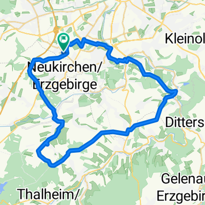
RR Tour Meerane
A cycling route starting in Neukirchen, Saxony, Germany.
Overview
About this route
Start: Altchemnitz Endhaltestelle
about 45 min to OE Oberlungwitz
another 30 min to Löbsdorf
Glauchau also Dresdner Str., Kantstr. possible
both with little cobblestone
Flutrinne cycle path asphalt
HOT railway underpass Lungwitzer Str. closed
- -:--
- Duration
- 99.6 km
- Distance
- 423 m
- Ascent
- 388 m
- Descent
- ---
- Avg. speed
- ---
- Max. altitude

Route quality
Waytypes & surfaces along the route
Waytypes
Road
25.9 km
(26 %)
Quiet road
15.9 km
(16 %)
Surfaces
Paved
79.7 km
(80 %)
Asphalt
77.7 km
(78 %)
Paved (undefined)
2 km
(2 %)
Undefined
19.9 km
(20 %)
Route highlights
Points of interest along the route
Point of interest after 46.2 km
Steile Wand
Continue with Bikemap
Use, edit, or download this cycling route
You would like to ride RR Tour Meerane or customize it for your own trip? Here is what you can do with this Bikemap route:
Free features
- Save this route as favorite or in collections
- Copy & plan your own version of this route
- Split it into stages to create a multi-day tour
- Sync your route with Garmin or Wahoo
Premium features
Free trial for 3 days, or one-time payment. More about Bikemap Premium.
- Navigate this route on iOS & Android
- Export a GPX / KML file of this route
- Create your custom printout (try it for free)
- Download this route for offline navigation
Discover more Premium features.
Get Bikemap PremiumFrom our community
Other popular routes starting in Neukirchen
 Hügelige Runde bei Chemnitz
- Distance
- 34.1 km
- Ascent
- 717 m
- Descent
- 714 m
- Location
- Neukirchen, Saxony, Germany
 Eisenweg und Pfarrhübel über Eisnsiedel
- Distance
- 35.4 km
- Ascent
- 574 m
- Descent
- 572 m
- Location
- Neukirchen, Saxony, Germany
 Rundweg Totenstein, entspannt
- Distance
- 24 km
- Ascent
- 273 m
- Descent
- 271 m
- Location
- Neukirchen, Saxony, Germany
 500 Hm Trainingsrunde
- Distance
- 36.6 km
- Ascent
- 595 m
- Descent
- 595 m
- Location
- Neukirchen, Saxony, Germany
 Neukirchen - Lugau - Neukirchen
- Distance
- 28.1 km
- Ascent
- 197 m
- Descent
- 193 m
- Location
- Neukirchen, Saxony, Germany
 Erzgebirgstour
- Distance
- 96.5 km
- Ascent
- 1,517 m
- Descent
- 1,494 m
- Location
- Neukirchen, Saxony, Germany
 Chemnitz - Südböhmen - Südmähren
- Distance
- 844.3 km
- Ascent
- 2,001 m
- Descent
- 2,130 m
- Location
- Neukirchen, Saxony, Germany
 Wasserschloßweg, Chemnitz nach An der Markthalle, Chemnitz
- Distance
- 19 km
- Ascent
- 244 m
- Descent
- 282 m
- Location
- Neukirchen, Saxony, Germany
Open it in the app