

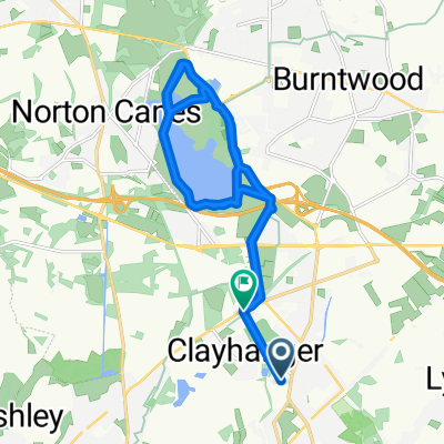
SPONSORED ROUTE 14.5 miles
A cycling route starting in Brownhills, England, United Kingdom.
Overview
About this route
Start from St James 10am
cycle to Lichfield road (Smithy Forge Pub) McClean Way. Cycle along track (if dry) to A5 Watling street. (alternative route if wet, cycle along road to A5) turn right. Continue straight on at island to the small turning on left LIONS DEN.
At T junction turn left along Coppice Lane. Continue to T junction meets A461 and turn LEFT.
Continue down hill at PIPEHILL (straight on at both islands) onto the Walsall Road. Continue straight on over small island.
Turn LEFT up CHRISTCHURCH LANE to 1st Church. (photo time)
Coninue on path alongside church meeting up over Western By pass to the Ntional Cycle Route
Cycle through Beacon Park towards the toilets opposite Minster Pool. (toilet Stop if needed)
Turn LEFT and RIGHT up The CLOSE to LICHFIELD CATHEDRAL (small book shops signs form) (photo time)
Cycle round back of Cathedral along National Cycle Network Route 54 at the side of STOWE POOL turn RIGHT to ST CHADS. (Photo time)
To the end of the road TURN RIGHT onto NETHERSTOWE. Turn LEFT onto St Chads Road leading onto St Michaels Rd. Keep going until you meet the main road A5127 TRENT VALLEY RD. Turn RIGHT to Traffic Lights then LEFT through Church gates and up hill to ST MICHAELS CHURCH. (Photo Time)
Back down onto CHURCH STREET Turn RIGHT onto GREENHILL leading onto TAMWORTH STREET and BORE STREET. TURN LEFT onto ST JOHNS STREET. (Photo time)
To Traffic Lights TURN RIGHT along BIRMINHAM RD, Straighton at island along SAINTE FOY AVE. TURN RIGHT at 2nd Island onto MAXTOCK AVENUE, Turn RIGHT onto DEYKIN RD towards DARWIN PARK, Turn LEFT and continue on DEYKIN RD to island. STRAIGHT on at Island to WALNUT WALK, follow rd to POOLFIELD RD and turn RIGHT - Continue straight on to Idland and turn LEFT onto the WALSALL ROAD
STRAIGHT ON at island. Continue up PIPEHILL (Good Luck)
Turn RIGHT into COPPICE LANE and back to THE LIONS DEN, Turn RIGHT onto A5
CHOICE (back along Mc CLeans way or the Rd)STRAIGHT on to McCleans WAY and back to church.
OR turn LEFT at Island up towards BArracks Lane. at island TURN RIGHT onto LICHFIELD RD, continue up hill and past Grasmere GArden Centre to Traffic LIGHTs. TURN LEFT onto OGLEY ROAD. 2nd ISLAND Turn RIGHT into VICARAGE RD and back to starting point.
- -:--
- Duration
- 23.5 km
- Distance
- 153 m
- Ascent
- 152 m
- Descent
- ---
- Avg. speed
- ---
- Max. altitude
Continue with Bikemap
Use, edit, or download this cycling route
You would like to ride SPONSORED ROUTE 14.5 miles or customize it for your own trip? Here is what you can do with this Bikemap route:
Free features
- Save this route as favorite or in collections
- Copy & plan your own version of this route
- Sync your route with Garmin or Wahoo
Premium features
Free trial for 3 days, or one-time payment. More about Bikemap Premium.
- Navigate this route on iOS & Android
- Export a GPX / KML file of this route
- Create your custom printout (try it for free)
- Download this route for offline navigation
Discover more Premium features.
Get Bikemap PremiumFrom our community
Other popular routes starting in Brownhills
 26 Barrow Close, Walsall to 26 Barrow Close, Walsall
- Distance
- 23.4 km
- Ascent
- 112 m
- Descent
- 117 m
- Location
- Brownhills, England, United Kingdom
 SPONSORED ROUTE 14.5 miles
- Distance
- 23.5 km
- Ascent
- 153 m
- Descent
- 152 m
- Location
- Brownhills, England, United Kingdom
 69 Hussey Road, Walsall to 71 Hussey Road, Walsall
- Distance
- 2.1 km
- Ascent
- 6 m
- Descent
- 24 m
- Location
- Brownhills, England, United Kingdom
 45, Brownhills
- Distance
- 19 km
- Ascent
- 74 m
- Descent
- 77 m
- Location
- Brownhills, England, United Kingdom
 circle test
- Distance
- 3.9 km
- Ascent
- 24 m
- Descent
- 22 m
- Location
- Brownhills, England, United Kingdom
 RIDE AND STRIDE
- Distance
- 16.8 km
- Ascent
- 82 m
- Descent
- 137 m
- Location
- Brownhills, England, United Kingdom
 10 Green Lane, Walsall to 26 Barrow Close, Walsall
- Distance
- 9.6 km
- Ascent
- 23 m
- Descent
- 37 m
- Location
- Brownhills, England, United Kingdom
 ridgend brewery
- Distance
- 79.4 km
- Ascent
- 342 m
- Descent
- 343 m
- Location
- Brownhills, England, United Kingdom
Open it in the app