Tour alla scoperta del Passo Mendola e dei Masi di Ruffrè
A cycling route starting in Ruffrè, Trentino-Alto Adige, Italy.
Overview
About this route
Itinerario vario e divertenteche alterna boschi, paesi, masi, maneggi, fattorie e punti panoramici sulle Dolomiti di Brenta e sulla Val d'Adige.
- 2 h 10 min
- Duration
- 19.1 km
- Distance
- 754 m
- Ascent
- 757 m
- Descent
- 8.8 km/h
- Avg. speed
- ---
- Avg. speed
Route quality
Waytypes & surfaces along the route
Waytypes
Quiet road
12.3 km
(64 %)
Busy road
2.1 km
(11 %)
Surfaces
Paved
12.1 km
(63 %)
Unpaved
2 km
(10 %)
Asphalt
11.7 km
(61 %)
Gravel
1.8 km
(9 %)
Continue with Bikemap
Use, edit, or download this cycling route
You would like to ride Tour alla scoperta del Passo Mendola e dei Masi di Ruffrè or customize it for your own trip? Here is what you can do with this Bikemap route:
Free features
- Save this route as favorite or in collections
- Copy & plan your own version of this route
- Sync your route with Garmin or Wahoo
Premium features
Free trial for 3 days, or one-time payment. More about Bikemap Premium.
- Navigate this route on iOS & Android
- Export a GPX / KML file of this route
- Create your custom printout (try it for free)
- Download this route for offline navigation
Discover more Premium features.
Get Bikemap PremiumFrom our community
Other popular routes starting in Ruffrè
- Ruffre/Trentino/Südtirol'14: Ruffre - Lago di Molveno - Ruffre
- Distance
- 111.4 km
- Ascent
- 1,965 m
- Descent
- 1,983 m
- Location
- Ruffrè, Trentino-Alto Adige, Italy
- I_Südtirol_Mendelpass-Falchetto-Prinzhütte-Penegal-Weg515-514-500_RR-19km-600hm
- Distance
- 19 km
- Ascent
- 611 m
- Descent
- 620 m
- Location
- Ruffrè, Trentino-Alto Adige, Italy
- Mendola Castrin Palade
- Distance
- 96.8 km
- Ascent
- 2,824 m
- Descent
- 2,788 m
- Location
- Ruffrè, Trentino-Alto Adige, Italy
- Tour alla scoperta del Passo Mendola e dei Masi di Ruffrè
- Distance
- 19.1 km
- Ascent
- 754 m
- Descent
- 757 m
- Location
- Ruffrè, Trentino-Alto Adige, Italy
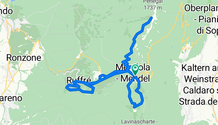
- Mendelpass - Penegal - Kaltern - Weinstrasse
- Distance
- 39.1 km
- Ascent
- 877 m
- Descent
- 2,021 m
- Location
- Ruffrè, Trentino-Alto Adige, Italy
- mendel-tonale-gavia-stilfserjoch-prad
- Distance
- 158.7 km
- Ascent
- 3,947 m
- Descent
- 4,392 m
- Location
- Ruffrè, Trentino-Alto Adige, Italy
- 2012_Monte Penegal (1727 m)
- Distance
- 3.9 km
- Ascent
- 390 m
- Descent
- 18 m
- Location
- Ruffrè, Trentino-Alto Adige, Italy
- Mendelpass - Mezzolombardo
- Distance
- 40.5 km
- Ascent
- 52 m
- Descent
- 1,181 m
- Location
- Ruffrè, Trentino-Alto Adige, Italy
Open it in the app