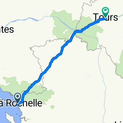
Ré-J1
A cycling route starting in La Rochelle, Nouvelle-Aquitaine, France.
Overview
About this route
- -:--
- Duration
- 22.4 km
- Distance
- 59 m
- Ascent
- 56 m
- Descent
- ---
- Avg. speed
- ---
- Max. altitude
Route quality
Waytypes & surfaces along the route
Waytypes
Cycleway
8.7 km
(39 %)
Quiet road
6.3 km
(28 %)
Surfaces
Paved
16.8 km
(75 %)
Unpaved
1.3 km
(6 %)
Asphalt
13.9 km
(62 %)
Concrete
1.8 km
(8 %)
Route highlights
Points of interest along the route
Point of interest after 12.4 km
vue du pont
Point of interest after 17.1 km
fort la pré
Point of interest after 19 km
abbaye des chateliers
Point of interest after 22.4 km
musée du platin
Point of interest after 22.4 km
marché de la flotte
Continue with Bikemap
Use, edit, or download this cycling route
You would like to ride Ré-J1 or customize it for your own trip? Here is what you can do with this Bikemap route:
Free features
- Save this route as favorite or in collections
- Copy & plan your own version of this route
- Sync your route with Garmin or Wahoo
Premium features
Free trial for 3 days, or one-time payment. More about Bikemap Premium.
- Navigate this route on iOS & Android
- Export a GPX / KML file of this route
- Create your custom printout (try it for free)
- Download this route for offline navigation
Discover more Premium features.
Get Bikemap PremiumFrom our community
Other popular routes starting in La Rochelle
- La Rochelle/Marsilly/Esnandes/côte nord
- Distance
- 34.6 km
- Ascent
- 63 m
- Descent
- 62 m
- Location
- La Rochelle, Nouvelle-Aquitaine, France
- La Rochelle vers Ballon par les chemins
- Distance
- 27.5 km
- Ascent
- 87 m
- Descent
- 77 m
- Location
- La Rochelle, Nouvelle-Aquitaine, France
- Boucle La Rochelle-Marais-océan
- Distance
- 18.1 km
- Ascent
- 33 m
- Descent
- 39 m
- Location
- La Rochelle, Nouvelle-Aquitaine, France
- 2016J05Jour : Visite île de Ré
- Distance
- 91.3 km
- Ascent
- 60 m
- Descent
- 56 m
- Location
- La Rochelle, Nouvelle-Aquitaine, France
- La Rochelle côte nord retour Canal de Marans
- Distance
- 46.9 km
- Ascent
- 77 m
- Descent
- 79 m
- Location
- La Rochelle, Nouvelle-Aquitaine, France
- La Rochelle / (les charmilles) rochefort
- Distance
- 28.4 km
- Ascent
- 60 m
- Descent
- 49 m
- Location
- La Rochelle, Nouvelle-Aquitaine, France
- France2023 E27
- Distance
- 68.4 km
- Ascent
- 123 m
- Descent
- 118 m
- Location
- La Rochelle, Nouvelle-Aquitaine, France
- La Rochelle to Ile de Re lighthouse return
- Distance
- 91.6 km
- Ascent
- 79 m
- Descent
- 81 m
- Location
- La Rochelle, Nouvelle-Aquitaine, France
Open it in the app