
Sustentur Alcoutim Tour
A cycling route starting in Alcoutim, Faro District, Portugal.
Overview
About this route
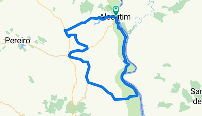
Start and end of the route – Alcoutim – Near the quay
Difficulty level – Difficult
Duration – Approximately 3h at an average speed of about 12 km/h
Elevation – 510m of climbing
GPS coordinates: 37.47135, -7.47126
Distance: 36.2km
A challenging route in the inland region worth doing. Its start is easy, following along the bank of the Guadiana River with stunning landscapes. On the other side, you can observe Spanish territory. In the town of Montinho das Laranjeiras, you can visit the ancient Roman village. After passing Guerreiros do Rio, you face the demanding climb that goes through Corte das Donas until reaching Balurcos.
The return to Alcoutim is made via Corte Tabelião. The panoramic views over the village, the river, and Sanlúcar on the Spanish side are breathtaking! On hotter days, take the opportunity to refresh yourself at the river beach.
- -:--
- Duration
- 36.2 km
- Distance
- 654 m
- Ascent
- 648 m
- Descent
- ---
- Avg. speed
- ---
- Max. altitude

Route quality
Waytypes & surfaces along the route
Waytypes
Road
25.7 km
(71 %)
Quiet road
1.1 km
(3 %)
Surfaces
Paved
13.8 km
(38 %)
Asphalt
12.7 km
(35 %)
Paved (undefined)
1.1 km
(3 %)
Undefined
22.4 km
(62 %)
Continue with Bikemap
Use, edit, or download this cycling route
You would like to ride Sustentur Alcoutim Tour or customize it for your own trip? Here is what you can do with this Bikemap route:
Free features
- Save this route as favorite or in collections
- Copy & plan your own version of this route
- Sync your route with Garmin or Wahoo
Premium features
Free trial for 3 days, or one-time payment. More about Bikemap Premium.
- Navigate this route on iOS & Android
- Export a GPX / KML file of this route
- Create your custom printout (try it for free)
- Download this route for offline navigation
Discover more Premium features.
Get Bikemap PremiumFrom our community
Other popular routes starting in Alcoutim
 Alcoutim Touring Tour
- Distance
- 36.4 km
- Ascent
- 654 m
- Descent
- 648 m
- Location
- Alcoutim, Faro District, Portugal
 Troféu Alpendre Internacional do Guadiana 2015 (2ª etapa)
- Distance
- 161 km
- Ascent
- 1,011 m
- Descent
- 1,085 m
- Location
- Alcoutim, Faro District, Portugal
 Sustentur Alcoutim Tour
- Distance
- 36.2 km
- Ascent
- 654 m
- Descent
- 648 m
- Location
- Alcoutim, Faro District, Portugal
 Almodovar 3. Etappe
- Distance
- 65.2 km
- Ascent
- 507 m
- Descent
- 242 m
- Location
- Alcoutim, Faro District, Portugal
 Algarviana1 Alcautim - Vaqueiros
- Distance
- 40 km
- Ascent
- 573 m
- Descent
- 373 m
- Location
- Alcoutim, Faro District, Portugal
 1- Alcoutim 66Km 740m
- Distance
- 66.5 km
- Ascent
- 555 m
- Descent
- 554 m
- Location
- Alcoutim, Faro District, Portugal
 Day 1.1 - S1 Alcoutim - Balurcos
- Distance
- 23.3 km
- Ascent
- 557 m
- Descent
- 376 m
- Location
- Alcoutim, Faro District, Portugal
 TRACK 003
- Distance
- 42.7 km
- Ascent
- 415 m
- Descent
- 415 m
- Location
- Alcoutim, Faro District, Portugal
Open it in the app