
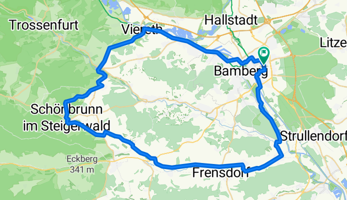
Durchs Rauhe Ebrach-Tal nach Schönbrunn im Steigerwald
A cycling route starting in Bamberg, Bavaria, Germany.
Overview
About this route
Von Bamberg zur Schleuse und nach Bug, am Bruderwald entlang nach Pettstadt. Mit Steigerwald-Radweg über Reundorf, Abtsdorf, Oberharnsbach, Grasmannsdorf (7 Brückenheilige), Ampferbach und Niederdorf nach Schönbrunn im Steigerwald. Einkehr Brauerei Wernsdörfer). Weiter mit Anstieg über Grub nach Lisberg. Abfahrt, dann rechts am Alten Kurhaus vorbei nach Trabelsdorf, wieder klettern und vorsichtig!! abfahren nach Weiher (Brauerei Kundmüller). Hinab nach Viereth, im Maintal rechts aufwärts über Bischberg und Gaustadt zurück nach Bamberg.
- -:--
- Duration
- 53.7 km
- Distance
- 404 m
- Ascent
- 404 m
- Descent
- ---
- Avg. speed
- 364 m
- Avg. speed
Route quality
Waytypes & surfaces along the route
Waytypes
Quiet road
23.9 km
(45 %)
Path
10.8 km
(20 %)
Surfaces
Paved
44.2 km
(82 %)
Unpaved
1.6 km
(3 %)
Asphalt
42.5 km
(79 %)
Gravel
1.5 km
(3 %)
Route highlights
Points of interest along the route
Point of interest after 29.4 km
Brauerei Wernsdörfer
Point of interest after 32.1 km
Gasthof Krug
Point of interest after 39.2 km
Brauerei Kundmüller
Continue with Bikemap
Use, edit, or download this cycling route
You would like to ride Durchs Rauhe Ebrach-Tal nach Schönbrunn im Steigerwald or customize it for your own trip? Here is what you can do with this Bikemap route:
Free features
- Save this route as favorite or in collections
- Copy & plan your own version of this route
- Sync your route with Garmin or Wahoo
Premium features
Free trial for 3 days, or one-time payment. More about Bikemap Premium.
- Navigate this route on iOS & Android
- Export a GPX / KML file of this route
- Create your custom printout (try it for free)
- Download this route for offline navigation
Discover more Premium features.
Get Bikemap PremiumFrom our community
Other popular routes starting in Bamberg
 Kleine Fränkische
- Distance
- 87.8 km
- Ascent
- 1,064 m
- Descent
- 1,008 m
- Location
- Bamberg, Bavaria, Germany
 Bamberger Wälder 1
- Distance
- 38.2 km
- Ascent
- 692 m
- Descent
- 662 m
- Location
- Bamberg, Bavaria, Germany
 Ba - Friesner Warte
- Distance
- 41.8 km
- Ascent
- 632 m
- Descent
- 610 m
- Location
- Bamberg, Bavaria, Germany
 Juraberge
- Distance
- 105.1 km
- Ascent
- 811 m
- Descent
- 807 m
- Location
- Bamberg, Bavaria, Germany
 Aurach- und Maintal-Rundtour
- Distance
- 63.4 km
- Ascent
- 284 m
- Descent
- 284 m
- Location
- Bamberg, Bavaria, Germany
 OFR_TeuchatzerB_Gügel
- Distance
- 41.3 km
- Ascent
- 481 m
- Descent
- 480 m
- Location
- Bamberg, Bavaria, Germany
 Übern Berg zur B22
- Distance
- 69.7 km
- Ascent
- 519 m
- Descent
- 501 m
- Location
- Bamberg, Bavaria, Germany
 Hauptsmoorwald-Mountainbikerunde
- Distance
- 36.5 km
- Ascent
- 529 m
- Descent
- 529 m
- Location
- Bamberg, Bavaria, Germany
Open it in the app