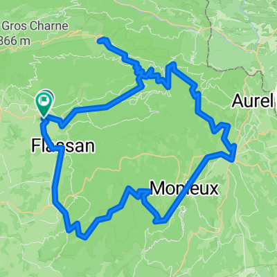
P40 Tour 4 - Mont Ventoux
A cycling route starting in Bédoin, Provence-Alpes-Côte d'Azur Region, France.
Overview
About this route
Start in Bédoin, zum Gipfel über die Südrampe via Le Chalet-Reynard, Abfahrt über Malaucène, zurück nach Bédoin
- -:--
- Duration
- 54.6 km
- Distance
- 1,673 m
- Ascent
- 1,673 m
- Descent
- ---
- Avg. speed
- ---
- Max. altitude
Continue with Bikemap
Use, edit, or download this cycling route
You would like to ride P40 Tour 4 - Mont Ventoux or customize it for your own trip? Here is what you can do with this Bikemap route:
Free features
- Save this route as favorite or in collections
- Copy & plan your own version of this route
- Sync your route with Garmin or Wahoo
Premium features
Free trial for 3 days, or one-time payment. More about Bikemap Premium.
- Navigate this route on iOS & Android
- Export a GPX / KML file of this route
- Create your custom printout (try it for free)
- Download this route for offline navigation
Discover more Premium features.
Get Bikemap PremiumFrom our community
Other popular routes starting in Bédoin
 Chemin des Crans, Bédoin to Cours de la République, Caromb Chemin des Crans, Bédoin to Cours de la République, Caromb- Distance
- 8.7 km
- Ascent
- 87 m
- Descent
- 185 m
- Location
- Bédoin, Provence-Alpes-Côte d'Azur Region, France
 
 Ventoux - Enduro Face nord Ventoux - Enduro Face nord- Distance
- 23.6 km
- Ascent
- 13 m
- Descent
- 1,584 m
- Location
- Bédoin, Provence-Alpes-Côte d'Azur Region, France
 
 Bedoin - Mt. Ventoux Bedoin - Mt. Ventoux- Distance
- 21.1 km
- Ascent
- 1,595 m
- Descent
- 127 m
- Location
- Bédoin, Provence-Alpes-Côte d'Azur Region, France
 
 Mont Ventoux Bédoin, Malaucène, Sault Mont Ventoux Bédoin, Malaucène, Sault- Distance
- 136.1 km
- Ascent
- 4,222 m
- Descent
- 4,222 m
- Location
- Bédoin, Provence-Alpes-Côte d'Azur Region, France
 
 Bédoin-Flassan-Nesque-Sault-Méthamis-Mormoiron Bédoin-Flassan-Nesque-Sault-Méthamis-Mormoiron- Distance
- 83.5 km
- Ascent
- 898 m
- Descent
- 901 m
- Location
- Bédoin, Provence-Alpes-Côte d'Azur Region, France
 
 Bedoin-Garomb Bedoin-Garomb- Distance
- 21.4 km
- Ascent
- 374 m
- Descent
- 374 m
- Location
- Bédoin, Provence-Alpes-Côte d'Azur Region, France
 
 Route in Bédoin Route in Bédoin- Distance
- 39.6 km
- Ascent
- 720 m
- Descent
- 718 m
- Location
- Bédoin, Provence-Alpes-Côte d'Azur Region, France
 
 Route in Bédoin Route in Bédoin- Distance
- 80.6 km
- Ascent
- 3,078 m
- Descent
- 3,085 m
- Location
- Bédoin, Provence-Alpes-Côte d'Azur Region, France
 
Open it in the app


