

tatton circular
A cycling route starting in Croft, England, United Kingdom.
Overview
About this route
-
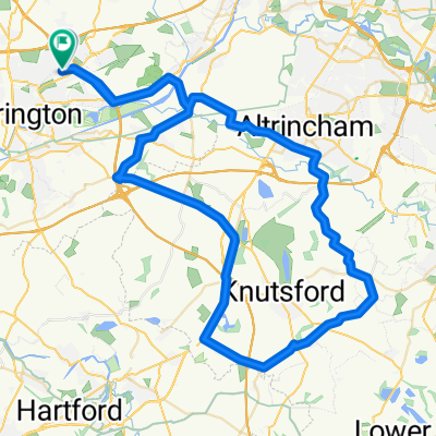
head to warby toll bridge. once over the bridge, follow the road to la bohmem. Turn left just after (MILL LANE)
-
this becomes BURFORD LANE
-
at the cross junction, go straight over into HIGH LEIGH road, this becomes WEST LANE.
-
go over the motorway and pick up the cycle route 70 to the left.
-
Follow the route and once on BROAD OAK lane nr mobberley leave the route to the right onto KNUTSFORD road to the right. this cecomed MOBERLEY road.
-
Turn right as the road joins brook street heading for the a50 (manchester road) follow this into mere and cross the A556 and carry on.....
-
before hitting the M56 turn RIGHT down MAG LANE.
-
Turn LEFT into CROUCHELY LANE and left onto CHURCH ROAD
-
follow through lymm and head home..
- -:--
- Duration
- 55.5 km
- Distance
- 135 m
- Ascent
- 135 m
- Descent
- ---
- Avg. speed
- ---
- Max. altitude

Continue with Bikemap
Use, edit, or download this cycling route
You would like to ride tatton circular or customize it for your own trip? Here is what you can do with this Bikemap route:
Free features
- Save this route as favorite or in collections
- Copy & plan your own version of this route
- Sync your route with Garmin or Wahoo
Premium features
Free trial for 3 days, or one-time payment. More about Bikemap Premium.
- Navigate this route on iOS & Android
- Export a GPX / KML file of this route
- Create your custom printout (try it for free)
- Download this route for offline navigation
Discover more Premium features.
Get Bikemap PremiumFrom our community
Other popular routes starting in Croft
 mini lymm route
- Distance
- 26.4 km
- Ascent
- 59 m
- Descent
- 61 m
- Location
- Croft, England, United Kingdom
 knutsfors peeover route
- Distance
- 69.8 km
- Ascent
- 146 m
- Descent
- 149 m
- Location
- Croft, England, United Kingdom
 appleton, stretton, daresbury 29.5mile
- Distance
- 47.5 km
- Ascent
- 143 m
- Descent
- 143 m
- Location
- Croft, England, United Kingdom
 to dan's
- Distance
- 6.7 km
- Ascent
- 8 m
- Descent
- 8 m
- Location
- Croft, England, United Kingdom
 leigh 18 miler
- Distance
- 29.4 km
- Ascent
- 65 m
- Descent
- 66 m
- Location
- Croft, England, United Kingdom
 OTO Day 1 Stoke
- Distance
- 72.7 km
- Ascent
- 235 m
- Descent
- 127 m
- Location
- Croft, England, United Kingdom
 14–15 Delenty Drive, Warrington to 14–15 Delenty Drive, Warrington
- Distance
- 23.6 km
- Ascent
- 88 m
- Descent
- 88 m
- Location
- Croft, England, United Kingdom
 stretton - warburton loop
- Distance
- 54.6 km
- Ascent
- 144 m
- Descent
- 142 m
- Location
- Croft, England, United Kingdom
Open it in the app