

Munich to Bad Tölz via Wolfratshausen
A cycling route starting in Munich, Bavaria, Germany.
Overview
About this route
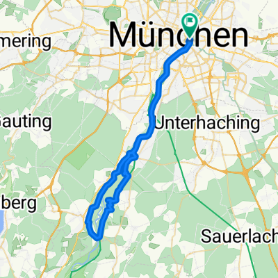
Start off in the center of Munich and follow the Isar to Grünwald with high river views, then some gravel paths to Strasslach through the forest.
From Strasslach, a quick descent to the Isar by the Mühltal and go along the canal paths to Aumühle.
Then more canal paths, a few bridges and unused road to Pupping to Wolfratshausen. Continue inland towards Konigsdorf and Bad Tölz.
Total distance: 63 km Total
- -:--
- Duration
- 63 km
- Distance
- 405 m
- Ascent
- 233 m
- Descent
- ---
- Avg. speed
- ---
- Avg. speed
Continue with Bikemap
Use, edit, or download this cycling route
You would like to ride Munich to Bad Tölz via Wolfratshausen or customize it for your own trip? Here is what you can do with this Bikemap route:
Free features
- Save this route as favorite or in collections
- Copy & plan your own version of this route
- Sync your route with Garmin or Wahoo
Premium features
Free trial for 3 days, or one-time payment. More about Bikemap Premium.
- Navigate this route on iOS & Android
- Export a GPX / KML file of this route
- Create your custom printout (try it for free)
- Download this route for offline navigation
Discover more Premium features.
Get Bikemap PremiumFrom our community
Other popular routes starting in Munich
 München- Woflrathshausen
- Distance
- 31.3 km
- Ascent
- 246 m
- Descent
- 190 m
- Location
- Munich, Bavaria, Germany
 München - Tölz - Königsdorf - München
- Distance
- 124.7 km
- Ascent
- 589 m
- Descent
- 587 m
- Location
- Munich, Bavaria, Germany
 Isar Süd Trainings Klassiker
- Distance
- 48.2 km
- Ascent
- 345 m
- Descent
- 345 m
- Location
- Munich, Bavaria, Germany
 München - Bruckmühl
- Distance
- 102.8 km
- Ascent
- 609 m
- Descent
- 589 m
- Location
- Munich, Bavaria, Germany
 Alpen 01 München-Tölz
- Distance
- 58 km
- Ascent
- 242 m
- Descent
- 134 m
- Location
- Munich, Bavaria, Germany
 Walchensee Runde
- Distance
- 160.7 km
- Ascent
- 1,159 m
- Descent
- 1,008 m
- Location
- Munich, Bavaria, Germany
 bikedress Hell of North PR 12_04_2015
- Distance
- 116.5 km
- Ascent
- 418 m
- Descent
- 417 m
- Location
- Munich, Bavaria, Germany
 münchen - miesbach
- Distance
- 106.6 km
- Ascent
- 422 m
- Descent
- 422 m
- Location
- Munich, Bavaria, Germany
Open it in the app