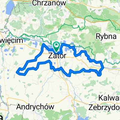
Wiślana Trasa Rowerowa - Małopolska
A cycling route starting in Zator, Lesser Poland Voivodeship, Poland.
Overview
About this route
- -:--
- Duration
- 47.8 km
- Distance
- 41 m
- Ascent
- 34 m
- Descent
- ---
- Avg. speed
- ---
- Avg. speed
Route photos
Route quality
Waytypes & surfaces along the route
Waytypes
Cycleway
16.6 km
(35 %)
Busy road
11.9 km
(25 %)
Surfaces
Paved
36.6 km
(77 %)
Unpaved
0.9 km
(2 %)
Asphalt
33.4 km
(70 %)
Paving stones
2.3 km
(5 %)
Continue with Bikemap
Use, edit, or download this cycling route
You would like to ride Wiślana Trasa Rowerowa - Małopolska or customize it for your own trip? Here is what you can do with this Bikemap route:
Free features
- Save this route as favorite or in collections
- Copy & plan your own version of this route
- Sync your route with Garmin or Wahoo
Premium features
Free trial for 3 days, or one-time payment. More about Bikemap Premium.
- Navigate this route on iOS & Android
- Export a GPX / KML file of this route
- Create your custom printout (try it for free)
- Download this route for offline navigation
Discover more Premium features.
Get Bikemap PremiumFrom our community
Other popular routes starting in Zator
- Zator i okolice
- Distance
- 47.6 km
- Ascent
- 500 m
- Descent
- 499 m
- Location
- Zator, Lesser Poland Voivodeship, Poland
- Trasa 3 (miniA) - Poranny śpiew ptasiej grobli (B)
- Distance
- 17.1 km
- Ascent
- 23 m
- Descent
- 20 m
- Location
- Zator, Lesser Poland Voivodeship, Poland
- Dolina Karpia - Pętla
- Distance
- 40.2 km
- Ascent
- 54 m
- Descent
- 52 m
- Location
- Zator, Lesser Poland Voivodeship, Poland
- Cycle Poland 2013: day 2
- Distance
- 122.9 km
- Ascent
- 526 m
- Descent
- 481 m
- Location
- Zator, Lesser Poland Voivodeship, Poland
- Zator - Oswiecim - Rajsko - Osiek - Zator
- Distance
- 53.5 km
- Ascent
- 114 m
- Descent
- 111 m
- Location
- Zator, Lesser Poland Voivodeship, Poland
- Podolsze-Kraków
- Distance
- 45.3 km
- Ascent
- 269 m
- Descent
- 270 m
- Location
- Zator, Lesser Poland Voivodeship, Poland
- Wiślana Trasa Rowerowa - Małopolska
- Distance
- 47.8 km
- Ascent
- 41 m
- Descent
- 34 m
- Location
- Zator, Lesser Poland Voivodeship, Poland
- Trasa 3 (miniB) - Poranny śpiew ptasiej grobli (B)
- Distance
- 16.6 km
- Ascent
- 35 m
- Descent
- 36 m
- Location
- Zator, Lesser Poland Voivodeship, Poland
Open it in the app