
Trilha Fantasma
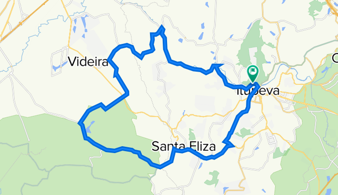
A cycling route starting in Itupeva, São Paulo, Brazil.
Overview
About this route
Statistics calculated from imported data
Distance: 40.5 km Minimum elevation: 611 m Maximum elevation: 771 m Total ascent: 414 m Total descent: 406 m
- -:--
- Duration
- 40.5 km
- Distance
- 562 m
- Ascent
- 560 m
- Descent
- ---
- Avg. speed
- ---
- Max. altitude

Route quality
Waytypes & surfaces along the route
Waytypes
Road
27.5 km
(68 %)
Quiet road
3.6 km
(9 %)
Undefined
9.3 km
(23 %)
Surfaces
Paved
13.8 km
(34 %)
Unpaved
8.1 km
(20 %)
Asphalt
9.3 km
(23 %)
Ground
7.7 km
(19 %)
Continue with Bikemap
Use, edit, or download this cycling route
You would like to ride Trilha Fantasma or customize it for your own trip? Here is what you can do with this Bikemap route:
Free features
- Save this route as favorite or in collections
- Copy & plan your own version of this route
- Sync your route with Garmin or Wahoo
Premium features
Free trial for 3 days, or one-time payment. More about Bikemap Premium.
- Navigate this route on iOS & Android
- Export a GPX / KML file of this route
- Create your custom printout (try it for free)
- Download this route for offline navigation
Discover more Premium features.
Get Bikemap PremiumFrom our community
Other popular routes starting in Itupeva
 Rota Caminho do Amor
- Distance
- 21.5 km
- Ascent
- 329 m
- Descent
- 331 m
- Location
- Itupeva, São Paulo, Brazil
 Trilha Fantasma
- Distance
- 40.5 km
- Ascent
- 562 m
- Descent
- 560 m
- Location
- Itupeva, São Paulo, Brazil
 Itupeva 34,6km Alt 510m (Evangelo)
- Distance
- 34.7 km
- Ascent
- 574 m
- Descent
- 575 m
- Location
- Itupeva, São Paulo, Brazil
 Medeiros - Eloy Chaves - Rondon
- Distance
- 15 km
- Ascent
- 255 m
- Descent
- 289 m
- Location
- Itupeva, São Paulo, Brazil
 De Avenida Reynaldo de Porcari 3010 a Avenida Reynaldo de Porcari 2788
- Distance
- 32.1 km
- Ascent
- 689 m
- Descent
- 667 m
- Location
- Itupeva, São Paulo, Brazil
 Rota P
- Distance
- 18.9 km
- Ascent
- 402 m
- Descent
- 400 m
- Location
- Itupeva, São Paulo, Brazil
 Quilombo + Foga
- Distance
- 34.5 km
- Ascent
- 544 m
- Descent
- 550 m
- Location
- Itupeva, São Paulo, Brazil
 Limoeiro-Nei32km42alt
- Distance
- 31.8 km
- Ascent
- 480 m
- Descent
- 480 m
- Location
- Itupeva, São Paulo, Brazil
Open it in the app