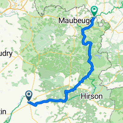
Recovered Route
A cycling route starting in Guise, Nord-Pas-de-Calais-Picardie, France.
Overview
About this route
- 1 h 31 min
- Duration
- 25.9 km
- Distance
- 295 m
- Ascent
- 294 m
- Descent
- 17.1 km/h
- Avg. speed
- ---
- Avg. speed
Route quality
Waytypes & surfaces along the route
Waytypes
Track
9 km
(35 %)
Quiet road
8.9 km
(34 %)
Surfaces
Paved
2.1 km
(8 %)
Unpaved
10.3 km
(40 %)
Ground
4.5 km
(17 %)
Unpaved (undefined)
4.4 km
(17 %)
Continue with Bikemap
Use, edit, or download this cycling route
You would like to ride Recovered Route or customize it for your own trip? Here is what you can do with this Bikemap route:
Free features
- Save this route as favorite or in collections
- Copy & plan your own version of this route
- Sync your route with Garmin or Wahoo
Premium features
Free trial for 3 days, or one-time payment. More about Bikemap Premium.
- Navigate this route on iOS & Android
- Export a GPX / KML file of this route
- Create your custom printout (try it for free)
- Download this route for offline navigation
Discover more Premium features.
Get Bikemap PremiumFrom our community
Other popular routes starting in Guise
- Lesquielles-Saint-Germain to Etreaupont
- Distance
- 26.4 km
- Ascent
- 109 m
- Descent
- 120 m
- Location
- Guise, Nord-Pas-de-Calais-Picardie, France
- De 46–56 Rue du Jeu de Paume, Guise à 89 Boulevard Jean Jaurès, Guise
- Distance
- 23.2 km
- Ascent
- 397 m
- Descent
- 398 m
- Location
- Guise, Nord-Pas-de-Calais-Picardie, France
- Recovered Route
- Distance
- 2.2 km
- Ascent
- 41 m
- Descent
- 28 m
- Location
- Guise, Nord-Pas-de-Calais-Picardie, France
- #03 Guise - Soissons
- Distance
- 86.8 km
- Ascent
- 540 m
- Descent
- 581 m
- Location
- Guise, Nord-Pas-de-Calais-Picardie, France
- De 103 Boulevard Jean Jaurès, Guise à 77 Boulevard Jean Jaurès, Guise
- Distance
- 35.4 km
- Ascent
- 396 m
- Descent
- 396 m
- Location
- Guise, Nord-Pas-de-Calais-Picardie, France
- BXL Saint Jean étape 2
- Distance
- 138.3 km
- Ascent
- 174 m
- Descent
- 191 m
- Location
- Guise, Nord-Pas-de-Calais-Picardie, France
- 264–344 Rue Camille Desmoulins, Guise nach 34 Rue de l'Armistice, Pierrefonds
- Distance
- 99.8 km
- Ascent
- 388 m
- Descent
- 398 m
- Location
- Guise, Nord-Pas-de-Calais-Picardie, France
- B 6 Guise - Amiens
- Distance
- 120.7 km
- Ascent
- 250 m
- Descent
- 324 m
- Location
- Guise, Nord-Pas-de-Calais-Picardie, France
Open it in the app