Saalhoehe - Staffelegg
A cycling route starting in Wallisellen / Rieden, Canton of Zurich, Switzerland.
Overview
About this route
- -:--
- Duration
- 147.3 km
- Distance
- 1,276 m
- Ascent
- 1,292 m
- Descent
- ---
- Avg. speed
- ---
- Max. altitude
Route quality
Waytypes & surfaces along the route
Waytypes
Quiet road
41.3 km
(28 %)
Road
32.4 km
(22 %)
Surfaces
Paved
107.6 km
(73 %)
Unpaved
16.2 km
(11 %)
Asphalt
106.1 km
(72 %)
Gravel
13.3 km
(9 %)
Continue with Bikemap
Use, edit, or download this cycling route
You would like to ride Saalhoehe - Staffelegg or customize it for your own trip? Here is what you can do with this Bikemap route:
Free features
- Save this route as favorite or in collections
- Copy & plan your own version of this route
- Split it into stages to create a multi-day tour
- Sync your route with Garmin or Wahoo
Premium features
Free trial for 3 days, or one-time payment. More about Bikemap Premium.
- Navigate this route on iOS & Android
- Export a GPX / KML file of this route
- Create your custom printout (try it for free)
- Download this route for offline navigation
Discover more Premium features.
Get Bikemap PremiumFrom our community
Other popular routes starting in Wallisellen / Rieden
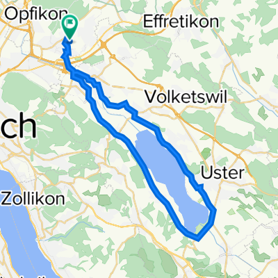
- Wallisellen - Greifensee Rundkurs
- Distance
- 32.1 km
- Ascent
- 175 m
- Descent
- 173 m
- Location
- Wallisellen / Rieden, Canton of Zurich, Switzerland
- Short ride from Wallisellen to Zürich
- Distance
- 4.8 km
- Ascent
- 4 m
- Descent
- 39 m
- Location
- Wallisellen / Rieden, Canton of Zurich, Switzerland
- Extensive Donnerstag Course In Wallisellen
- Distance
- 10 km
- Ascent
- 0 m
- Descent
- 0 m
- Location
- Wallisellen / Rieden, Canton of Zurich, Switzerland
- Wallisellen-Kramhof
- Distance
- 10 km
- Ascent
- 64 m
- Descent
- 127 m
- Location
- Wallisellen / Rieden, Canton of Zurich, Switzerland
- Riedenerstrasse 39, Wallisellen nach Bahnhaldenstrasse 12, Zürich
- Distance
- 22.2 km
- Ascent
- 319 m
- Descent
- 338 m
- Location
- Wallisellen / Rieden, Canton of Zurich, Switzerland
- Obere Kirchstrasse 44, Wallisellen to Grindelstrasse 6, Wallisellen
- Distance
- 1.3 km
- Ascent
- 7 m
- Descent
- 31 m
- Location
- Wallisellen / Rieden, Canton of Zurich, Switzerland
- Schäfligrabenstrasse 32, Wallisellen nach Dorfstrasse 32, Opfikon
- Distance
- 22.4 km
- Ascent
- 960 m
- Descent
- 992 m
- Location
- Wallisellen / Rieden, Canton of Zurich, Switzerland
- Schäfligrabenstrasse 23, Wallisellen nach Schäfligrabenstrasse 45, Wallisellen
- Distance
- 24.6 km
- Ascent
- 147 m
- Descent
- 142 m
- Location
- Wallisellen / Rieden, Canton of Zurich, Switzerland
Open it in the app