

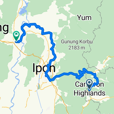
201006 Cameron Highlands 100km Ride
A cycling route starting in Tanah Rata, Pahang, Malaysia.
Overview
About this route
Relax ride from Hotel de la Fern to the summit at Brinchang and head down towards Ipoh for 50km before turning back to starting point.
- -:--
- Duration
- 100.3 km
- Distance
- 1,634 m
- Ascent
- 1,634 m
- Descent
- ---
- Avg. speed
- ---
- Max. altitude

Continue with Bikemap
Use, edit, or download this cycling route
You would like to ride 201006 Cameron Highlands 100km Ride or customize it for your own trip? Here is what you can do with this Bikemap route:
Free features
- Save this route as favorite or in collections
- Copy & plan your own version of this route
- Split it into stages to create a multi-day tour
- Sync your route with Garmin or Wahoo
Premium features
Free trial for 3 days, or one-time payment. More about Bikemap Premium.
- Navigate this route on iOS & Android
- Export a GPX / KML file of this route
- Create your custom printout (try it for free)
- Download this route for offline navigation
Discover more Premium features.
Get Bikemap PremiumFrom our community
Other popular routes starting in Tanah Rata
 J11-Malaisie_Ringlet-Brinchang-07-03-2011
- Distance
- 16.8 km
- Ascent
- 607 m
- Descent
- 215 m
- Location
- Tanah Rata, Pahang, Malaysia
 tanah rata - raub
- Distance
- 50.9 km
- Ascent
- 305 m
- Descent
- 1,362 m
- Location
- Tanah Rata, Pahang, Malaysia
 Rawang - Cameron Highlands
- Distance
- 187.8 km
- Ascent
- 399 m
- Descent
- 1,746 m
- Location
- Tanah Rata, Pahang, Malaysia
 Cameron H - Kuala Kansar
- Distance
- 172.6 km
- Ascent
- 511 m
- Descent
- 1,903 m
- Location
- Tanah Rata, Pahang, Malaysia
 201006 Cameron Highlands 100km Ride
- Distance
- 100.3 km
- Ascent
- 1,634 m
- Descent
- 1,634 m
- Location
- Tanah Rata, Pahang, Malaysia
 J48 - Tanah Rata - Kuala Lipis
- Distance
- 134.3 km
- Ascent
- 387 m
- Descent
- 1,750 m
- Location
- Tanah Rata, Pahang, Malaysia
 brichang - fossy forests
- Distance
- 25 km
- Ascent
- 711 m
- Descent
- 708 m
- Location
- Tanah Rata, Pahang, Malaysia
 J12-Malaisie_Brinchang-Sungai Siput-08-03-2011
- Distance
- 114.3 km
- Ascent
- 503 m
- Descent
- 1,914 m
- Location
- Tanah Rata, Pahang, Malaysia
Open it in the app