
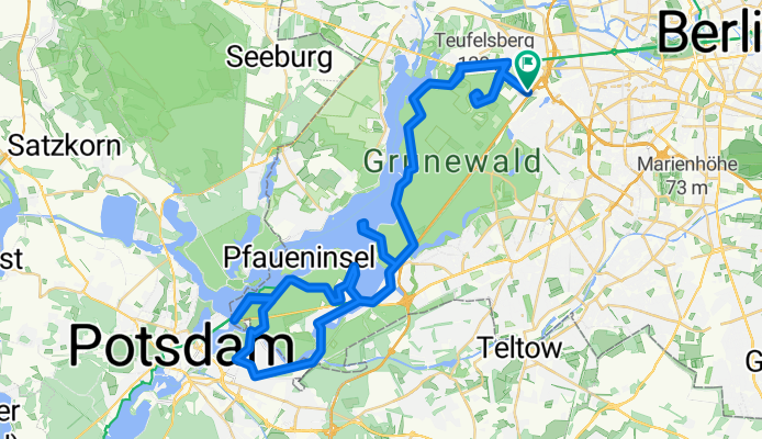
Hügelrunde entlang der Havel
A cycling route starting in Grunewald, State of Berlin, Germany.
Overview
About this route
at least over 500 hm
- -:--
- Duration
- 71.4 km
- Distance
- 594 m
- Ascent
- 584 m
- Descent
- ---
- Avg. speed
- 94 m
- Max. altitude

Route quality
Waytypes & surfaces along the route
Waytypes
Quiet road
30 km
(42 %)
Road
24.3 km
(34 %)
Surfaces
Paved
68.6 km
(96 %)
Unpaved
1.4 km
(2 %)
Asphalt
67.1 km
(94 %)
Concrete
1.4 km
(2 %)
Continue with Bikemap
Use, edit, or download this cycling route
You would like to ride Hügelrunde entlang der Havel or customize it for your own trip? Here is what you can do with this Bikemap route:
Free features
- Save this route as favorite or in collections
- Copy & plan your own version of this route
- Sync your route with Garmin or Wahoo
Premium features
Free trial for 3 days, or one-time payment. More about Bikemap Premium.
- Navigate this route on iOS & Android
- Export a GPX / KML file of this route
- Create your custom printout (try it for free)
- Download this route for offline navigation
Discover more Premium features.
Get Bikemap PremiumFrom our community
Other popular routes starting in Grunewald
 Schwielowsee-Feierabendrunde
- Distance
- 83.8 km
- Ascent
- 349 m
- Descent
- 346 m
- Location
- Grunewald, State of Berlin, Germany
 Drei Berge bei Potsdam
- Distance
- 82.4 km
- Ascent
- 305 m
- Descent
- 309 m
- Location
- Grunewald, State of Berlin, Germany
 Grüne Strecke MTB
- Distance
- 19 km
- Ascent
- 185 m
- Descent
- 194 m
- Location
- Grunewald, State of Berlin, Germany
 Grunewald und Havelstadt
- Distance
- 45.6 km
- Ascent
- 109 m
- Descent
- 128 m
- Location
- Grunewald, State of Berlin, Germany
 S-Grunewald zum Flämingskate
- Distance
- 151.5 km
- Ascent
- 163 m
- Descent
- 153 m
- Location
- Grunewald, State of Berlin, Germany
 wannsee route 2010
- Distance
- 49.8 km
- Ascent
- 321 m
- Descent
- 321 m
- Location
- Grunewald, State of Berlin, Germany
 Südrunde 100km April
- Distance
- 100.8 km
- Ascent
- 292 m
- Descent
- 300 m
- Location
- Grunewald, State of Berlin, Germany
 RTF RCC Marathon CLONED FROM ROUTE 155493
- Distance
- 139.4 km
- Ascent
- 210 m
- Descent
- 193 m
- Location
- Grunewald, State of Berlin, Germany
Open it in the app