

0111a Kruft Nickenich Eich
A cycling route starting in Weißenthurm, Rhineland-Palatinate, Germany.
Overview
About this route
Over Weißenthurm and Saffig to Plaidt, then Kruft (ice cream shop Lung), back via Nickenich, Eich, and Andernach. Start at the Rhine Bridge Neuwied
- -:--
- Duration
- 34.1 km
- Distance
- 261 m
- Ascent
- 265 m
- Descent
- ---
- Avg. speed
- ---
- Max. altitude

Route quality
Waytypes & surfaces along the route
Waytypes
Quiet road
12.3 km
(36 %)
Track
8.9 km
(26 %)
Surfaces
Paved
17.7 km
(52 %)
Unpaved
3.1 km
(9 %)
Asphalt
15.7 km
(46 %)
Ground
2 km
(6 %)
Continue with Bikemap
Use, edit, or download this cycling route
You would like to ride 0111a Kruft Nickenich Eich or customize it for your own trip? Here is what you can do with this Bikemap route:
Free features
- Save this route as favorite or in collections
- Copy & plan your own version of this route
- Sync your route with Garmin or Wahoo
Premium features
Free trial for 3 days, or one-time payment. More about Bikemap Premium.
- Navigate this route on iOS & Android
- Export a GPX / KML file of this route
- Create your custom printout (try it for free)
- Download this route for offline navigation
Discover more Premium features.
Get Bikemap PremiumFrom our community
Other popular routes starting in Weißenthurm
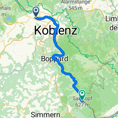 Weißenthurm - Bacharach
- Distance
- 68.4 km
- Ascent
- 627 m
- Descent
- 585 m
- Location
- Weißenthurm, Rhineland-Palatinate, Germany
 Weißenth_Mayen_Bassenheim-Rundtour
- Distance
- 57.9 km
- Ascent
- 370 m
- Descent
- 370 m
- Location
- Weißenthurm, Rhineland-Palatinate, Germany
 Weißenthurm_Laacher See_Runde
- Distance
- 45.4 km
- Ascent
- 340 m
- Descent
- 346 m
- Location
- Weißenthurm, Rhineland-Palatinate, Germany
 Efteling - Tag 18
- Distance
- 76.5 km
- Ascent
- 129 m
- Descent
- 138 m
- Location
- Weißenthurm, Rhineland-Palatinate, Germany
 Nette-Obst-Radrunde ü. Plaidt45 km
- Distance
- 44.7 km
- Ascent
- 422 m
- Descent
- 422 m
- Location
- Weißenthurm, Rhineland-Palatinate, Germany
 Nette-Obst-Radrunde ü. Plaidt45 km - Nette-Obst-Radrunde ü. Plaidt45 km
- Distance
- 44.6 km
- Ascent
- 228 m
- Descent
- 228 m
- Location
- Weißenthurm, Rhineland-Palatinate, Germany
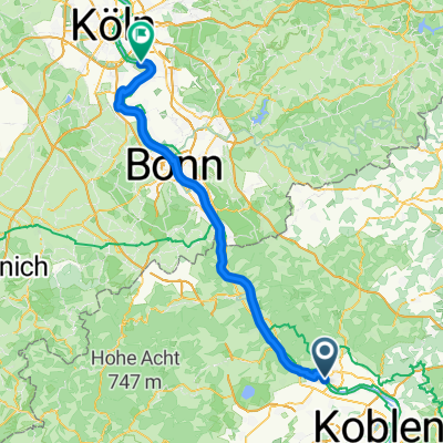
 Weißenthurm - Niederkassel
- Distance
- 62.1 km
- Ascent
- 384 m
- Descent
- 399 m
- Location
- Weißenthurm, Rhineland-Palatinate, Germany
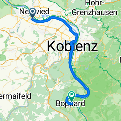 Weißenthurm - Boppard
- Distance
- 39.6 km
- Ascent
- 211 m
- Descent
- 201 m
- Location
- Weißenthurm, Rhineland-Palatinate, Germany
Open it in the app