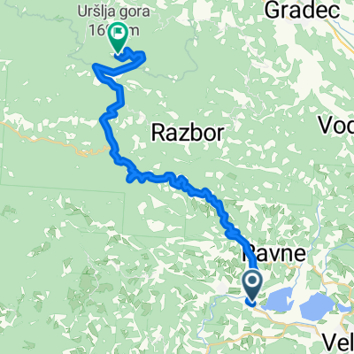
Dravograd - Celje 2.del poti varianta B
A cycling route starting in Šoštanj, Občina Šoštanj, Slovenia.
Overview
About this route
- -:--
- Duration
- 38.4 km
- Distance
- 354 m
- Ascent
- 467 m
- Descent
- ---
- Avg. speed
- ---
- Max. altitude
Route quality
Waytypes & surfaces along the route
Waytypes
Road
23.4 km
(61 %)
Quiet road
8.8 km
(23 %)
Surfaces
Paved
13 km
(34 %)
Asphalt
13 km
(34 %)
Undefined
25.3 km
(66 %)
Route highlights
Points of interest along the route
Point of interest after 4.7 km
Velenjska plaža
Point of interest after 7.8 km
Velenjski grad nedelja 10-18
Point of interest after 20.9 km
Jama Pekel nedelja ob 10, 12, 14 in 16, novo v nedeljo ob 17. ogled z lastnimi lučkami
Point of interest after 38.4 km
Stari grad Celje nedelja 9-21
Point of interest after 38.4 km
Pokrajinski muzej Celje nedelja 10-18
Point of interest after 38.4 km
Herkulovo svetišče odprto 24 ur
Point of interest after 38.4 km
Vodni stolp odprto 24 ur
Continue with Bikemap
Use, edit, or download this cycling route
You would like to ride Dravograd - Celje 2.del poti varianta B or customize it for your own trip? Here is what you can do with this Bikemap route:
Free features
- Save this route as favorite or in collections
- Copy & plan your own version of this route
- Sync your route with Garmin or Wahoo
Premium features
Free trial for 3 days, or one-time payment. More about Bikemap Premium.
- Navigate this route on iOS & Android
- Export a GPX / KML file of this route
- Create your custom printout (try it for free)
- Download this route for offline navigation
Discover more Premium features.
Get Bikemap PremiumFrom our community
Other popular routes starting in Šoštanj
- Florjan Šmartno ob Paki Prebold Polzela Velenje
- Distance
- 53.6 km
- Ascent
- 698 m
- Descent
- 702 m
- Location
- Šoštanj, Občina Šoštanj, Slovenia
- Dravograd - Celje 2.del poti varianta B
- Distance
- 38.4 km
- Ascent
- 354 m
- Descent
- 467 m
- Location
- Šoštanj, Občina Šoštanj, Slovenia
- Trg svobode 5 to Migojnice 4b
- Distance
- 109.9 km
- Ascent
- 2,142 m
- Descent
- 2,219 m
- Location
- Šoštanj, Občina Šoštanj, Slovenia
- Škale-Forhtenek-Zavodnje-Topolšica
- Distance
- 30.3 km
- Ascent
- 717 m
- Descent
- 712 m
- Location
- Šoštanj, Občina Šoštanj, Slovenia
- svtina
- Distance
- 101.2 km
- Ascent
- 716 m
- Descent
- 722 m
- Location
- Šoštanj, Občina Šoštanj, Slovenia
- Šoštanj-Križan-Rampa-Uršlja
- Distance
- 26.5 km
- Ascent
- 1,467 m
- Descent
- 142 m
- Location
- Šoštanj, Občina Šoštanj, Slovenia
- šoštanj - smrekovc
- Distance
- 46.7 km
- Ascent
- 1,264 m
- Descent
- 1,263 m
- Location
- Šoštanj, Občina Šoštanj, Slovenia
- Lokovica 8a to Lokovica 1b
- Distance
- 19.6 km
- Ascent
- 712 m
- Descent
- 727 m
- Location
- Šoštanj, Občina Šoštanj, Slovenia
Open it in the app