
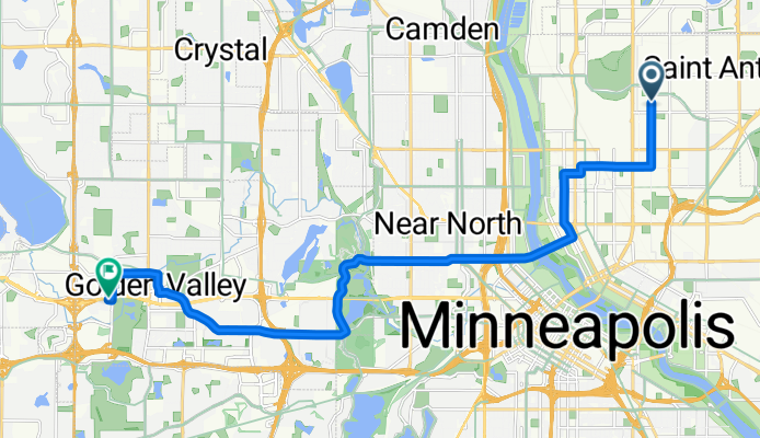
B2B00742 55418>55427 via 22nd Av NE, Plymouth Av N, Glenwood Av
A cycling route starting in Saint Anthony, Minnesota, United States.
Overview
About this route
- -:--
- Duration
- 17.9 km
- Distance
- 44 m
- Ascent
- 48 m
- Descent
- ---
- Avg. speed
- 277 m
- Max. altitude
Route quality
Waytypes & surfaces along the route
Waytypes
Road
7.4 km
(41 %)
Quiet road
4.3 km
(24 %)
Surfaces
Paved
17 km
(95 %)
Asphalt
8.1 km
(45 %)
Paved (undefined)
7 km
(39 %)
Route highlights
Points of interest along the route
Point of interest after 15.3 km
Can cross at intersection at light
Point of interest after 16 km
Can take Golden Valley Rd if comfortable with the traffic level.
Continue with Bikemap
Use, edit, or download this cycling route
You would like to ride B2B00742 55418>55427 via 22nd Av NE, Plymouth Av N, Glenwood Av or customize it for your own trip? Here is what you can do with this Bikemap route:
Free features
- Save this route as favorite or in collections
- Copy & plan your own version of this route
- Sync your route with Garmin or Wahoo
Premium features
Free trial for 3 days, or one-time payment. More about Bikemap Premium.
- Navigate this route on iOS & Android
- Export a GPX / KML file of this route
- Create your custom printout (try it for free)
- Download this route for offline navigation
Discover more Premium features.
Get Bikemap PremiumFrom our community
Other popular routes starting in Saint Anthony
 B2B0003055418>55403 via 27th, plymouth, and cedar lake bike path
- Distance
- 9.6 km
- Ascent
- 37 m
- Descent
- 51 m
- Location
- Saint Anthony, Minnesota, United States
 Silver Lake Plaza to 14th and Marshall
- Distance
- 8.3 km
- Ascent
- 8 m
- Descent
- 43 m
- Location
- Saint Anthony, Minnesota, United States
 B2B00064 55421>55447 via 44th, 29th, 35th, and rockford rd
- Distance
- 26.1 km
- Ascent
- 86 m
- Descent
- 80 m
- Location
- Saint Anthony, Minnesota, United States
 B2B00735 55418 > 55404 via Monroe St NE, Portland Ave
- Distance
- 8.6 km
- Ascent
- 54 m
- Descent
- 81 m
- Location
- Saint Anthony, Minnesota, United States
 B2B00379 55418 < 55108 via St. Anthony Pkwy, Industrial, Larpenteur
- Distance
- 8 km
- Ascent
- 51 m
- Descent
- 37 m
- Location
- Saint Anthony, Minnesota, United States
 Stone arch bridge
- Distance
- 16.2 km
- Ascent
- 81 m
- Descent
- 84 m
- Location
- Saint Anthony, Minnesota, United States
 B2B00776 55418>55104 via Mpls Diag Trl, Como Av, Western Av
- Distance
- 19.1 km
- Ascent
- 61 m
- Descent
- 78 m
- Location
- Saint Anthony, Minnesota, United States
 B2B00961 55418>55402 via MDT, 4th St SE, Portland Av
- Distance
- 7.4 km
- Ascent
- 63 m
- Descent
- 58 m
- Location
- Saint Anthony, Minnesota, United States
Open it in the app