

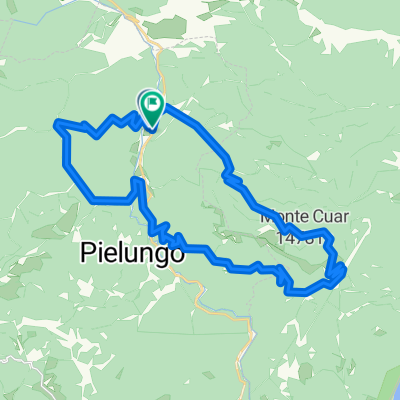
monte prat
A cycling route starting in Anduins, Friuli Venezia Giulia, Italy.
Overview
About this route
Mionte Prat Cuyel de Forchia, Pra Steppa, Malga Monte Cuar, Cuel de Forchiua, Mionte Prat (Forgaria)
- -:--
- Duration
- 27.4 km
- Distance
- 755 m
- Ascent
- 755 m
- Descent
- ---
- Avg. speed
- ---
- Max. altitude
Route quality
Waytypes & surfaces along the route
Waytypes
Track
15.4 km
(56 %)
Quiet road
12.1 km
(44 %)
Surfaces
Paved
3.8 km
(14 %)
Unpaved
14 km
(51 %)
Gravel
14 km
(51 %)
Asphalt
3.8 km
(14 %)
Undefined
9.6 km
(35 %)
Continue with Bikemap
Use, edit, or download this cycling route
You would like to ride monte prat or customize it for your own trip? Here is what you can do with this Bikemap route:
Free features
- Save this route as favorite or in collections
- Copy & plan your own version of this route
- Sync your route with Garmin or Wahoo
Premium features
Free trial for 3 days, or one-time payment. More about Bikemap Premium.
- Navigate this route on iOS & Android
- Export a GPX / KML file of this route
- Create your custom printout (try it for free)
- Download this route for offline navigation
Discover more Premium features.
Get Bikemap PremiumFrom our community
Other popular routes starting in Anduins
 Castello Ceconi da Anduins
- Distance
- 20.6 km
- Ascent
- 410 m
- Descent
- 410 m
- Location
- Anduins, Friuli Venezia Giulia, Italy
 prova san francesco
- Distance
- 36.3 km
- Ascent
- 1,539 m
- Descent
- 1,529 m
- Location
- Anduins, Friuli Venezia Giulia, Italy
 monte prat
- Distance
- 27.4 km
- Ascent
- 755 m
- Descent
- 755 m
- Location
- Anduins, Friuli Venezia Giulia, Italy
 Anello Prat BDC
- Distance
- 36.7 km
- Ascent
- 823 m
- Descent
- 823 m
- Location
- Anduins, Friuli Venezia Giulia, Italy
 Knorr Giro túra - Csütörtök Sella Chianzutan oda-vissza
- Distance
- 46.7 km
- Ascent
- 798 m
- Descent
- 798 m
- Location
- Anduins, Friuli Venezia Giulia, Italy
 Casera Sinich Bassa
- Distance
- 22.9 km
- Ascent
- 441 m
- Descent
- 172 m
- Location
- Anduins, Friuli Venezia Giulia, Italy
 Bottecchia Road + Laghi
- Distance
- 20.7 km
- Ascent
- 163 m
- Descent
- 144 m
- Location
- Anduins, Friuli Venezia Giulia, Italy
 Knorr Giro túra - Péntek Piancavallora
- Distance
- 61.7 km
- Ascent
- 1,246 m
- Descent
- 278 m
- Location
- Anduins, Friuli Venezia Giulia, Italy
Open it in the app