

TonisWeg_Kobenauserwald
A cycling route starting in Fornach, Upper Austria, Austria.
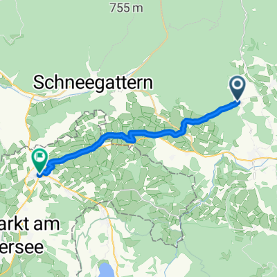
Overview
About this route
lässige Strecke durch wunderschöne Wälder
- -:--
- Duration
- 28.7 km
- Distance
- 500 m
- Ascent
- 472 m
- Descent
- ---
- Avg. speed
- ---
- Max. altitude

Route quality
Waytypes & surfaces along the route
Waytypes
Track
18.4 km
(64 %)
Road
7.3 km
(25 %)
Surfaces
Paved
1.5 km
(5 %)
Unpaved
17.4 km
(60 %)
Gravel
15.9 km
(55 %)
Asphalt
1.5 km
(5 %)
Continue with Bikemap
Use, edit, or download this cycling route
You would like to ride TonisWeg_Kobenauserwald or customize it for your own trip? Here is what you can do with this Bikemap route:
Free features
- Save this route as favorite or in collections
- Copy & plan your own version of this route
- Sync your route with Garmin or Wahoo
Premium features
Free trial for 3 days, or one-time payment. More about Bikemap Premium.
- Navigate this route on iOS & Android
- Export a GPX / KML file of this route
- Create your custom printout (try it for free)
- Download this route for offline navigation
Discover more Premium features.
Get Bikemap PremiumFrom our community
Other popular routes starting in Fornach
 Doppelmühle 14, Fornach nach Doppelmühle 14, Fornach
- Distance
- 30.5 km
- Ascent
- 302 m
- Descent
- 291 m
- Location
- Fornach, Upper Austria, Austria
 TonisWeg_Kobenauserwald
- Distance
- 28.7 km
- Ascent
- 500 m
- Descent
- 472 m
- Location
- Fornach, Upper Austria, Austria
 Fornach Radfahren
- Distance
- 18.6 km
- Ascent
- 128 m
- Descent
- 288 m
- Location
- Fornach, Upper Austria, Austria
 Saxigen 23 - Saxigen 23
- Distance
- 15.8 km
- Ascent
- 142 m
- Descent
- 196 m
- Location
- Fornach, Upper Austria, Austria
 Fornach - Strasswalchen
- Distance
- 14.5 km
- Ascent
- 207 m
- Descent
- 242 m
- Location
- Fornach, Upper Austria, Austria
 Maria Schmolln
- Distance
- 27.8 km
- Ascent
- 388 m
- Descent
- 399 m
- Location
- Fornach, Upper Austria, Austria
 tonisweg
- Distance
- 28.7 km
- Ascent
- 476 m
- Descent
- 461 m
- Location
- Fornach, Upper Austria, Austria
 para
para- Distance
- 15.8 km
- Ascent
- 272 m
- Descent
- 280 m
- Location
- Fornach, Upper Austria, Austria
Open it in the app