
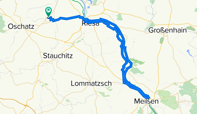
Waldweg 5, Liebschützberg nach Waldweg 5, Liebschützberg
A cycling route starting in Strehla, Saxony, Germany.
Overview
About this route
- 3 h 6 min
- Duration
- 71.8 km
- Distance
- 273 m
- Ascent
- 275 m
- Descent
- 23.2 km/h
- Avg. speed
- ---
- Max. altitude

Route quality
Waytypes & surfaces along the route
Waytypes
Path
24.4 km
(34 %)
Cycleway
13.8 km
(19 %)
Surfaces
Paved
56.8 km
(79 %)
Unpaved
2.1 km
(3 %)
Asphalt
49.6 km
(69 %)
Paving stones
6.3 km
(9 %)
Continue with Bikemap
Use, edit, or download this cycling route
You would like to ride Waldweg 5, Liebschützberg nach Waldweg 5, Liebschützberg or customize it for your own trip? Here is what you can do with this Bikemap route:
Free features
- Save this route as favorite or in collections
- Copy & plan your own version of this route
- Sync your route with Garmin or Wahoo
Premium features
Free trial for 3 days, or one-time payment. More about Bikemap Premium.
- Navigate this route on iOS & Android
- Export a GPX / KML file of this route
- Create your custom printout (try it for free)
- Download this route for offline navigation
Discover more Premium features.
Get Bikemap PremiumFrom our community
Other popular routes starting in Strehla
 Strehla gut
- Distance
- 35.2 km
- Ascent
- 66 m
- Descent
- 67 m
- Location
- Strehla, Saxony, Germany
 Tour de Petra 2012
- Distance
- 45 km
- Ascent
- 61 m
- Descent
- 61 m
- Location
- Strehla, Saxony, Germany
 RF Strehla 1: Elbfähre--Lorenzkirch--Jacobsthal--Tiefenau--Köselitz--Solarpark Zeithain--Zschepa--ERW--Lorenzkirch--Elbfähre--Strehla
- Distance
- 43 km
- Ascent
- 113 m
- Descent
- 114 m
- Location
- Strehla, Saxony, Germany
 Kreinitz - Dürrenberger Forst - Kreinitz
- Distance
- 37.4 km
- Ascent
- 181 m
- Descent
- 183 m
- Location
- Strehla, Saxony, Germany
 Streha - Dresden (Elberadweg)
- Distance
- 61.1 km
- Ascent
- 83 m
- Descent
- 75 m
- Location
- Strehla, Saxony, Germany
 RF Strehla 2: Elbfähre--Lorenzkirch--ERW--Borschütz--Mühlberg/E.--Elbbrücke Mühlberg--B 182/EV7--Außig--Lößnig--Gaststätte Nixstein--Strehla
- Distance
- 32.9 km
- Ascent
- 62 m
- Descent
- 61 m
- Location
- Strehla, Saxony, Germany
 Vom Elberadweg zum Senftenberger See
- Distance
- 79 km
- Ascent
- 48 m
- Descent
- 31 m
- Location
- Strehla, Saxony, Germany
 TdP 2019
- Distance
- 42.3 km
- Ascent
- 37 m
- Descent
- 37 m
- Location
- Strehla, Saxony, Germany
Open it in the app