Steve Landau 2024
- 75.9 km
- 1,195 m
- 1,190 m
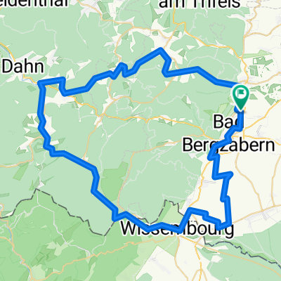
- Pleisweiler-Oberhofen, Rhineland-Palatinate, Germany
A cycling route starting in Pleisweiler-Oberhofen, Rhineland-Palatinate, Germany.
Overview
From Pleisweiler, we pass by the ruins of Landeck, along the Kling and Erlen streams to the Rhine meadows at Neupotz. On the Rhine dike, we ride through the nature and bird protection area between the Rhine and Altrhein to Wörth. Through the Bienwald, we head to Kandel. Noteworthy here are the church and the lovingly restored half-timbered houses. From Minfeld, we cycle back over the ridge with beautiful views to Bad Bergzabern or Pleisweiler.
created this 5 years ago
Route quality
Track
45.6 km
(64 %)
Quiet road
9.3 km
(13 %)
Paved
64.2 km
(90 %)
Unpaved
1.4 km
(2 %)
Asphalt
52 km
(73 %)
Concrete
8.6 km
(12 %)
Continue with Bikemap
You would like to ride Pfalz Rhein or customize it for your own trip? Here is what you can do with this Bikemap route:
Free trial for 3 days, or one-time payment. More about Bikemap Premium.
Discover more Premium features.
Get Bikemap PremiumFrom our community
Open it in the app