

Mädelstour 2020
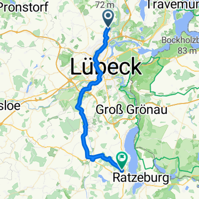
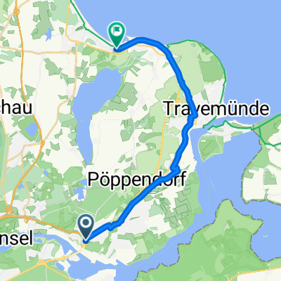
Herrentunnel-Ostsee-Pönitz-Pansdorf-HL
A cycling route starting in Bad Schwartau, Schleswig-Holstein, Germany.
Overview
About this route
- -:--
- Duration
- 57.3 km
- Distance
- 153 m
- Ascent
- 147 m
- Descent
- ---
- Avg. speed
- ---
- Max. altitude

Part of
Mädelstour 2020
6 stages
Route quality
Waytypes & surfaces along the route
Waytypes
Quiet road
28.7 km
(50 %)
Cycleway
14.9 km
(26 %)
Surfaces
Paved
45.3 km
(79 %)
Unpaved
5.7 km
(10 %)
Asphalt
43.6 km
(76 %)
Gravel
5.2 km
(9 %)
Continue with Bikemap
Use, edit, or download this cycling route
You would like to ride Herrentunnel-Ostsee-Pönitz-Pansdorf-HL or customize it for your own trip? Here is what you can do with this Bikemap route:
Free features
- Save this route as favorite or in collections
- Copy & plan your own version of this route
- Sync your route with Garmin or Wahoo
Premium features
Free trial for 3 days, or one-time payment. More about Bikemap Premium.
- Navigate this route on iOS & Android
- Export a GPX / KML file of this route
- Create your custom printout (try it for free)
- Download this route for offline navigation
Discover more Premium features.
Get Bikemap PremiumFrom our community
Other popular routes starting in Bad Schwartau
 1. Etappe - von Bad Schwartau über Krummesse /Berkenthin nach Einhaus
- Distance
- 36.2 km
- Ascent
- 224 m
- Descent
- 242 m
- Location
- Bad Schwartau, Schleswig-Holstein, Germany
 Radrunde durch Bad Schwartau
- Distance
- 12.3 km
- Ascent
- 24 m
- Descent
- 22 m
- Location
- Bad Schwartau, Schleswig-Holstein, Germany
 Ostholstein einfach nur schön 😊
- Distance
- 34 km
- Ascent
- 222 m
- Descent
- 226 m
- Location
- Bad Schwartau, Schleswig-Holstein, Germany
 Osterrundfahrt 1.Teil
- Distance
- 3.2 km
- Ascent
- 17 m
- Descent
- 17 m
- Location
- Bad Schwartau, Schleswig-Holstein, Germany
 Pariner Straße 36G nach Pariner Straße 36H
- Distance
- 29.7 km
- Ascent
- 209 m
- Descent
- 251 m
- Location
- Bad Schwartau, Schleswig-Holstein, Germany
 Herrentunnel Nord nach Strandallee
- Distance
- 16 km
- Ascent
- 56 m
- Descent
- 60 m
- Location
- Bad Schwartau, Schleswig-Holstein, Germany
 Osterrundfahrt 2.Teil
- Distance
- 15.1 km
- Ascent
- 85 m
- Descent
- 70 m
- Location
- Bad Schwartau, Schleswig-Holstein, Germany
 Schleichweg nach Travemünde, hinter Teerhofinsel entlang
- Distance
- 14.2 km
- Ascent
- 117 m
- Descent
- 153 m
- Location
- Bad Schwartau, Schleswig-Holstein, Germany
Open it in the app