

XC - St Martin de Belleville
XC - Du Doron au haut de Valtho
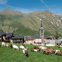
A cycling route starting in Saint-Martin-de-Belleville, Auvergne-Rhône-Alpes, France.
Overview
About this route
Combination of the xc 15 and 21 routes for a grand tour of Bellevilles to the top of Valtho
- -:--
- Duration
- 53 km
- Distance
- 1,866 m
- Ascent
- 1,826 m
- Descent
- ---
- Avg. speed
- ---
- Max. altitude

Part of
XC - St Martin de Belleville
7 stages
Route quality
Waytypes & surfaces along the route
Waytypes
Track
40.3 km
(76 %)
Quiet road
9 km
(17 %)
Surfaces
Paved
4.8 km
(9 %)
Unpaved
11.1 km
(21 %)
Asphalt
4.8 km
(9 %)
Unpaved (undefined)
4.2 km
(8 %)
Continue with Bikemap
Use, edit, or download this cycling route
You would like to ride XC - Du Doron au haut de Valtho or customize it for your own trip? Here is what you can do with this Bikemap route:
Free features
- Save this route as favorite or in collections
- Copy & plan your own version of this route
- Sync your route with Garmin or Wahoo
Premium features
Free trial for 3 days, or one-time payment. More about Bikemap Premium.
- Navigate this route on iOS & Android
- Export a GPX / KML file of this route
- Create your custom printout (try it for free)
- Download this route for offline navigation
Discover more Premium features.
Get Bikemap PremiumFrom our community
Other popular routes starting in Saint-Martin-de-Belleville
 Itinéraire modéré en Saint-Martin-de-Belleville
- Distance
- 3.1 km
- Ascent
- 0 m
- Descent
- 296 m
- Location
- Saint-Martin-de-Belleville, Auvergne-Rhône-Alpes, France
 XC - St Martin de Belleville + St Marcel - Débutant XC2
- Distance
- 7.2 km
- Ascent
- 187 m
- Descent
- 187 m
- Location
- Saint-Martin-de-Belleville, Auvergne-Rhône-Alpes, France
 Val Thorens
- Distance
- 17.2 km
- Ascent
- 975 m
- Descent
- 47 m
- Location
- Saint-Martin-de-Belleville, Auvergne-Rhône-Alpes, France
 St.Martin de belle Ville-Courchevel
- Distance
- 125.2 km
- Ascent
- 3,392 m
- Descent
- 3,022 m
- Location
- Saint-Martin-de-Belleville, Auvergne-Rhône-Alpes, France
 0813-Gittam-Lac Mont
- Distance
- 83.3 km
- Ascent
- 2,765 m
- Descent
- 2,320 m
- Location
- Saint-Martin-de-Belleville, Auvergne-Rhône-Alpes, France
 XC - St Martin - les Priots (xc 3)
- Distance
- 13.6 km
- Ascent
- 498 m
- Descent
- 498 m
- Location
- Saint-Martin-de-Belleville, Auvergne-Rhône-Alpes, France
 XC - Du Doron à Valtho+ en passant par le Lou
- Distance
- 56.9 km
- Ascent
- 2,075 m
- Descent
- 2,035 m
- Location
- Saint-Martin-de-Belleville, Auvergne-Rhône-Alpes, France
 XC - Doron - Menuires - Col de la fenêtre - Encombres
- Distance
- 39.6 km
- Ascent
- 1,293 m
- Descent
- 1,292 m
- Location
- Saint-Martin-de-Belleville, Auvergne-Rhône-Alpes, France
Open it in the app