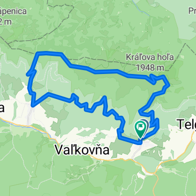
Iglói kör
A cycling route starting in Dobšiná, Košice Region, Slovakia.
Overview
About this route
Bicycle tour
- -:--
- Duration
- 64.7 km
- Distance
- 958 m
- Ascent
- 957 m
- Descent
- ---
- Avg. speed
- ---
- Max. altitude
Route quality
Waytypes & surfaces along the route
Waytypes
Track
26.5 km
(41 %)
Road
18.8 km
(29 %)
Surfaces
Paved
32.4 km
(50 %)
Unpaved
25.2 km
(39 %)
Asphalt
31.1 km
(48 %)
Gravel
11.6 km
(18 %)
Route highlights
Points of interest along the route
Point of interest after 36.4 km
Point of interest after 41.2 km
Continue with Bikemap
Use, edit, or download this cycling route
You would like to ride Iglói kör or customize it for your own trip? Here is what you can do with this Bikemap route:
Free features
- Save this route as favorite or in collections
- Copy & plan your own version of this route
- Sync your route with Garmin or Wahoo
Premium features
Free trial for 3 days, or one-time payment. More about Bikemap Premium.
- Navigate this route on iOS & Android
- Export a GPX / KML file of this route
- Create your custom printout (try it for free)
- Download this route for offline navigation
Discover more Premium features.
Get Bikemap PremiumFrom our community
Other popular routes starting in Dobšiná
Iglói kör- Distance
- 64.7 km
- Ascent
- 958 m
- Descent
- 957 m
- Location
- Dobšiná, Košice Region, Slovakia
Telgárt - Mlynky - Nálepkovo - Gelnica - Margecany - Košice- Distance
- 139.9 km
- Ascent
- 2,169 m
- Descent
- 2,837 m
- Location
- Dobšiná, Košice Region, Slovakia
Kráľova Hoľa- Distance
- 23.8 km
- Ascent
- 1,024 m
- Descent
- 1,009 m
- Location
- Dobšiná, Košice Region, Slovakia
SK/Telgárt - PL/Zakopane- Distance
- 98.8 km
- Ascent
- 1,877 m
- Descent
- 1,820 m
- Location
- Dobšiná, Košice Region, Slovakia
Šumiac, Kráľová Hoľa, Bartková,Pohorelá Šumiac- Distance
- 39.1 km
- Ascent
- 1,338 m
- Descent
- 1,337 m
- Location
- Dobšiná, Košice Region, Slovakia
Zelená stuha Horehronia- Distance
- 54.8 km
- Ascent
- 979 m
- Descent
- 1,246 m
- Location
- Dobšiná, Košice Region, Slovakia
Telgárt, Telgárt až Muráň- Distance
- 21.6 km
- Ascent
- 667 m
- Descent
- 694 m
- Location
- Dobšiná, Košice Region, Slovakia
KH-Certovica- Distance
- 42 km
- Ascent
- 1,110 m
- Descent
- 1,803 m
- Location
- Dobšiná, Košice Region, Slovakia
Open it in the app


