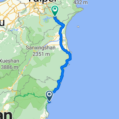
新城->太魯閣->天祥->水濂洞
- 27.9 km
- 2,258 m
- 1,492 m
- Hualien City, Taiwan, Taiwan
A cycling route starting in Hualien City, Taiwan, Taiwan.
Overview
臺灣花蓮擁有豐富的自然資源,壯闊海景與太魯閣峽谷。此項從太魯閣台八線騎自行車挑戰武嶺-台灣公路最高點的賽事,歷經海拔高度0公尺-3275公尺,可謂『前所未有、撼動世界』深具國際競爭力的賽事。比賽途中將穿越壯觀的黑暗隧道、通過多次不同的氣候變化、歷經曲折狹窄路面上下彎道,攀登至3275公尺台灣公路最高點-武嶺,這場融合了冒險元素超越極限的自行車挑戰行程,將告訴全世界--台灣的魅力。 比賽日期:2010年11月21日(星期日)AM05:00檢錄;PM13:30結束報到時間:11月20日 PM14:00-17:00 花蓮翰品飯店行前說明:11月20日 PM15:00 花蓮翰品飯店-會議室集合地點:花蓮縣秀林國中(花蓮縣新城鄉新城村中山路56號) 比賽路線:(一) 武嶺組:花蓮縣秀林國中→太魯閣大橋→太魯閣國家公園管理處→天祥→西寶→洛韶→新白楊→碧綠神木→中油關原站→武嶺,約90公里。(二)天祥組:花蓮縣秀林國中→太魯閣大橋→太魯閣國家公園管理處→天祥,約21公里。
created this 15 years ago
Route highlights
秀林鄉秀林國中
太魯閣大橋
太魯閣國家公園管理處
天祥
西寶
洛韶
新白楊
碧綠神木
中油關原站
武嶺
Continue with Bikemap
You would like to ride MAXXIS Taroko International Hill Climb 2010太魯閣國際登山賽 or customize it for your own trip? Here is what you can do with this Bikemap route:
Free trial for 3 days, or one-time payment. More about Bikemap Premium.
Discover more Premium features.
Get Bikemap PremiumFrom our community
Open it in the app