

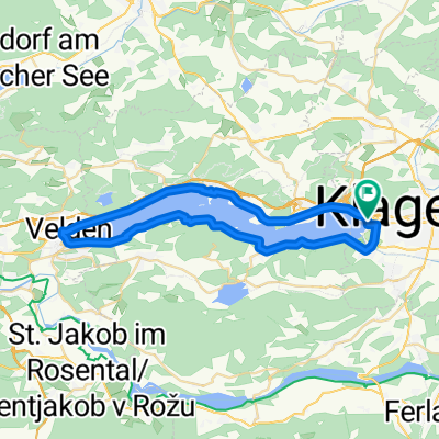
Wörthersee Höhenrundweg
A cycling route starting in Klagenfurt, Carinthia, Austria.
Overview
About this route
- -:--
- Duration
- 55.8 km
- Distance
- 1,243 m
- Ascent
- 1,240 m
- Descent
- ---
- Avg. speed
- ---
- Max. altitude

Continue with Bikemap
Use, edit, or download this cycling route
You would like to ride Wörthersee Höhenrundweg or customize it for your own trip? Here is what you can do with this Bikemap route:
Free features
- Save this route as favorite or in collections
- Copy & plan your own version of this route
- Sync your route with Garmin or Wahoo
Premium features
Free trial for 3 days, or one-time payment. More about Bikemap Premium.
- Navigate this route on iOS & Android
- Export a GPX / KML file of this route
- Create your custom printout (try it for free)
- Download this route for offline navigation
Discover more Premium features.
Get Bikemap PremiumFrom our community
Other popular routes starting in Klagenfurt
 Wörthersee roundtour
- Distance
- 40.5 km
- Ascent
- 515 m
- Descent
- 516 m
- Location
- Klagenfurt, Carinthia, Austria
 IRONMAN Austria (2006 - dato)
- Distance
- 89.4 km
- Ascent
- 1,188 m
- Descent
- 1,135 m
- Location
- Klagenfurt, Carinthia, Austria
 Wörthersee-Süduferstraße 55A, Klagenfurt am Wörthersee to Wörthersee-Süduferstraße 55A, Klagenfurt am Wörthersee
- Distance
- 45.1 km
- Ascent
- 306 m
- Descent
- 340 m
- Location
- Klagenfurt, Carinthia, Austria
 Ulrichsberg
- Distance
- 37.4 km
- Ascent
- 911 m
- Descent
- 910 m
- Location
- Klagenfurt, Carinthia, Austria
 Ostersonntag
- Distance
- 75.2 km
- Ascent
- 388 m
- Descent
- 389 m
- Location
- Klagenfurt, Carinthia, Austria
 Klagenfurt I
- Distance
- 29.4 km
- Ascent
- 65 m
- Descent
- 61 m
- Location
- Klagenfurt, Carinthia, Austria
 Klagenfurt Nord- Dürnstein
- Distance
- 34 km
- Ascent
- 234 m
- Descent
- 92 m
- Location
- Klagenfurt, Carinthia, Austria
 Unterkärnten extreme
- Distance
- 127.9 km
- Ascent
- 2,804 m
- Descent
- 2,780 m
- Location
- Klagenfurt, Carinthia, Austria
Open it in the app