

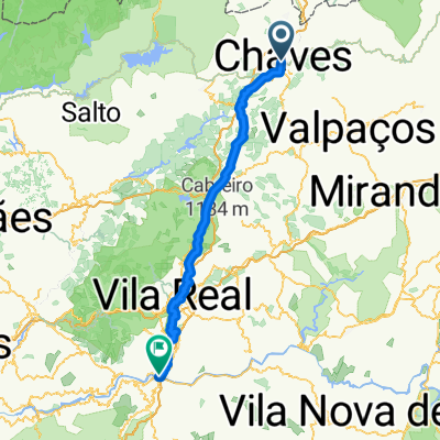
rota 3 santuários
A cycling route starting in Chaves, Vila Real District, Portugal.
Overview
About this route
- 4 h 37 min
- Duration
- 45.1 km
- Distance
- 941 m
- Ascent
- 943 m
- Descent
- 9.8 km/h
- Avg. speed
- ---
- Max. altitude

Route quality
Waytypes & surfaces along the route
Waytypes
Track
20.3 km
(45 %)
Quiet road
14 km
(31 %)
Surfaces
Paved
7.2 km
(16 %)
Unpaved
1.8 km
(4 %)
Asphalt
7.2 km
(16 %)
Ground
1.8 km
(4 %)
Undefined
36.1 km
(80 %)
Route highlights
Points of interest along the route
Point of interest after 13 km
Santuário de Nossa Senhora da Aparecida
Point of interest after 14.9 km
Santuário Nossa Senhora das Necessidades
Point of interest after 24.2 km
Santuário de São Caetano
Continue with Bikemap
Use, edit, or download this cycling route
You would like to ride rota 3 santuários or customize it for your own trip? Here is what you can do with this Bikemap route:
Free features
- Save this route as favorite or in collections
- Copy & plan your own version of this route
- Sync your route with Garmin or Wahoo
Premium features
Free trial for 3 days, or one-time payment. More about Bikemap Premium.
- Navigate this route on iOS & Android
- Export a GPX / KML file of this route
- Create your custom printout (try it for free)
- Download this route for offline navigation
Discover more Premium features.
Get Bikemap PremiumFrom our community
Other popular routes starting in Chaves
 Aniv18
- Distance
- 33.8 km
- Ascent
- 697 m
- Descent
- 698 m
- Location
- Chaves, Vila Real District, Portugal
 rota 3 santuários
- Distance
- 45.1 km
- Ascent
- 941 m
- Descent
- 943 m
- Location
- Chaves, Vila Real District, Portugal
 Chaves Régua pelas linhas do Comboio
- Distance
- 98.1 km
- Ascent
- 525 m
- Descent
- 823 m
- Location
- Chaves, Vila Real District, Portugal
 RPastel50
- Distance
- 45.4 km
- Ascent
- 737 m
- Descent
- 738 m
- Location
- Chaves, Vila Real District, Portugal
 Vidago-Xinzo de Limia
- Distance
- 85.3 km
- Ascent
- 387 m
- Descent
- 399 m
- Location
- Chaves, Vila Real District, Portugal
 Estrada Nacional 2 Etapa 1 (Chaves/Castro Daire)
- Distance
- 141.3 km
- Ascent
- 1,686 m
- Descent
- 1,545 m
- Location
- Chaves, Vila Real District, Portugal
 1. Chaves- Régua bahn Route
- Distance
- 95.6 km
- Ascent
- 1,899 m
- Descent
- 2,191 m
- Location
- Chaves, Vila Real District, Portugal
 Wikiloc - Von Chaves bis Peso da Régua - Von Chaves bis Peso da Régua
- Distance
- 103.6 km
- Ascent
- 2,307 m
- Descent
- 2,593 m
- Location
- Chaves, Vila Real District, Portugal
Open it in the app