Abstatt Weinsberg Weibertreu
A cycling route starting in Abstatt, Baden-Wurttemberg, Germany.
Overview
About this route
- -:--
- Duration
- 29.6 km
- Distance
- 378 m
- Ascent
- 378 m
- Descent
- ---
- Avg. speed
- ---
- Max. altitude
Route quality
Waytypes & surfaces along the route
Waytypes
Track
14.8 km
(50 %)
Quiet road
5.9 km
(20 %)
Surfaces
Paved
20.4 km
(69 %)
Unpaved
5 km
(17 %)
Asphalt
19.2 km
(65 %)
Gravel
2.4 km
(8 %)
Continue with Bikemap
Use, edit, or download this cycling route
You would like to ride Abstatt Weinsberg Weibertreu or customize it for your own trip? Here is what you can do with this Bikemap route:
Free features
- Save this route as favorite or in collections
- Copy & plan your own version of this route
- Sync your route with Garmin or Wahoo
Premium features
Free trial for 3 days, or one-time payment. More about Bikemap Premium.
- Navigate this route on iOS & Android
- Export a GPX / KML file of this route
- Create your custom printout (try it for free)
- Download this route for offline navigation
Discover more Premium features.
Get Bikemap PremiumFrom our community
Other popular routes starting in Abstatt
Abstatt - Kreuzbergsee- Distance
- 51.7 km
- Ascent
- 262 m
- Descent
- 313 m
- Location
- Abstatt, Baden-Wurttemberg, Germany
Auenstein - Kochertal -Neuhütten- Distance
- 100.8 km
- Ascent
- 453 m
- Descent
- 453 m
- Location
- Abstatt, Baden-Wurttemberg, Germany
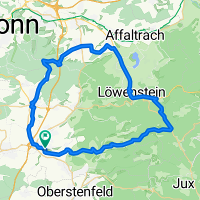
Schweinsbergrunde-Stage3_42km-800hm- Distance
- 41.6 km
- Ascent
- 437 m
- Descent
- 438 m
- Location
- Abstatt, Baden-Wurttemberg, Germany
BS_Wildeck-Söhlbach-Wartkopf-Wunnenstein-Auenstein-23km-600hm- Distance
- 23.3 km
- Ascent
- 503 m
- Descent
- 529 m
- Location
- Abstatt, Baden-Wurttemberg, Germany
Abstatt Weinsberg Weibertreu- Distance
- 29.6 km
- Ascent
- 378 m
- Descent
- 378 m
- Location
- Abstatt, Baden-Wurttemberg, Germany
Wildeck-Bleichsee-Vorhof-Annasee-600hm- Distance
- 24 km
- Ascent
- 486 m
- Descent
- 488 m
- Location
- Abstatt, Baden-Wurttemberg, Germany
BS_Gronau_lang_alternativ_Birk_Krugeich_Gronau_Wartkopf_Söhlbach_26km_570hm- Distance
- 26.3 km
- Ascent
- 550 m
- Descent
- 549 m
- Location
- Abstatt, Baden-Wurttemberg, Germany
Ilsfeld-Stettenfels-Köpfertal-Stausee-Flein- Distance
- 39.1 km
- Ascent
- 514 m
- Descent
- 513 m
- Location
- Abstatt, Baden-Wurttemberg, Germany
Open it in the app


