

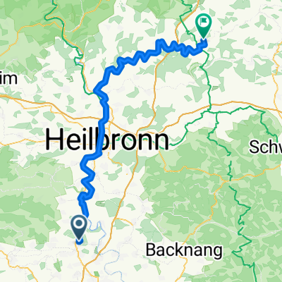
Bietigheim - Durch die Talauen der Enz
A cycling route starting in Bietigheim-Bissingen, Baden-Wurttemberg, Germany.
Overview
About this route
Eine Tour, die versucht, so wenig wie möglich Straßenkontakt zu haben - eine Radtour nicht nur für Familien!
- 1 h 36 min
- Duration
- 25.7 km
- Distance
- 165 m
- Ascent
- 168 m
- Descent
- 16 km/h
- Avg. speed
- ---
- Max. altitude
Route quality
Waytypes & surfaces along the route
Waytypes
Track
16.4 km
(64 %)
Path
3.8 km
(15 %)
Surfaces
Paved
22.1 km
(86 %)
Unpaved
3.1 km
(12 %)
Asphalt
16.7 km
(65 %)
Paved (undefined)
3.1 km
(12 %)
Continue with Bikemap
Use, edit, or download this cycling route
You would like to ride Bietigheim - Durch die Talauen der Enz or customize it for your own trip? Here is what you can do with this Bikemap route:
Free features
- Save this route as favorite or in collections
- Copy & plan your own version of this route
- Sync your route with Garmin or Wahoo
Premium features
Free trial for 3 days, or one-time payment. More about Bikemap Premium.
- Navigate this route on iOS & Android
- Export a GPX / KML file of this route
- Create your custom printout (try it for free)
- Download this route for offline navigation
Discover more Premium features.
Get Bikemap PremiumFrom our community
Other popular routes starting in Bietigheim-Bissingen
 3B-Land-Tour
- Distance
- 29.1 km
- Ascent
- 195 m
- Descent
- 195 m
- Location
- Bietigheim-Bissingen, Baden-Wurttemberg, Germany
 Schöne Runde
- Distance
- 37.5 km
- Ascent
- 295 m
- Descent
- 279 m
- Location
- Bietigheim-Bissingen, Baden-Wurttemberg, Germany
 Schulstraße 8, Bietigheim-Bissingen nach Schulstraße 15, Bietigheim-Bissingen
- Distance
- 54.2 km
- Ascent
- 452 m
- Descent
- 455 m
- Location
- Bietigheim-Bissingen, Baden-Wurttemberg, Germany
 3-B-Land-Tour Kraichgau Stromberg
- Distance
- 29.1 km
- Ascent
- 178 m
- Descent
- 176 m
- Location
- Bietigheim-Bissingen, Baden-Wurttemberg, Germany
 Goethestraße, Sachsenheim nach Wobachstraße, Bietigheim-Bissingen
- Distance
- 6.1 km
- Ascent
- 27 m
- Descent
- 85 m
- Location
- Bietigheim-Bissingen, Baden-Wurttemberg, Germany
 Jagst Kocher 1
- Distance
- 85.7 km
- Ascent
- 881 m
- Descent
- 829 m
- Location
- Bietigheim-Bissingen, Baden-Wurttemberg, Germany
 Bi-Marb-Grossb-Mundelsh-Besigh-Bi
- Distance
- 43.5 km
- Ascent
- 262 m
- Descent
- 261 m
- Location
- Bietigheim-Bissingen, Baden-Wurttemberg, Germany
 Sachsenheim-Horrheim-Vahingen und zurück
- Distance
- 29.6 km
- Ascent
- 200 m
- Descent
- 197 m
- Location
- Bietigheim-Bissingen, Baden-Wurttemberg, Germany
Open it in the app