
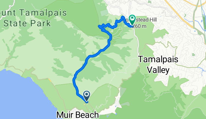
muir woods rd
A cycling route starting in Tamalpais Valley, California, United States.
Overview
About this route
distance: 3.927 miles <br />start: 22' <br />end: 718' <br />net gain: 696' <br />gradient: 3.4%
- -:--
- Duration
- 6.3 km
- Distance
- 358 m
- Ascent
- 160 m
- Descent
- ---
- Avg. speed
- ---
- Max. altitude
Route quality
Waytypes & surfaces along the route
Waytypes
Quiet road
6.3 km
(100 %)
Surfaces
Paved
4.2 km
(66 %)
Paved (undefined)
4.2 km
(66 %)
Undefined
2.2 km
(34 %)
Continue with Bikemap
Use, edit, or download this cycling route
You would like to ride muir woods rd or customize it for your own trip? Here is what you can do with this Bikemap route:
Free features
- Save this route as favorite or in collections
- Copy & plan your own version of this route
- Sync your route with Garmin or Wahoo
Premium features
Free trial for 3 days, or one-time payment. More about Bikemap Premium.
- Navigate this route on iOS & Android
- Export a GPX / KML file of this route
- Create your custom printout (try it for free)
- Download this route for offline navigation
Discover more Premium features.
Get Bikemap PremiumFrom our community
Other popular routes starting in Tamalpais Valley
 Muir Beach to Muir Wood (as walked)
- Distance
- 30.4 km
- Ascent
- 805 m
- Descent
- 805 m
- Location
- Tamalpais Valley, California, United States
 Pirates Cove Trail, Mill Valley to 15 Corte Del Coronado, Larkspur
- Distance
- 16.6 km
- Ascent
- 165 m
- Descent
- 336 m
- Location
- Tamalpais Valley, California, United States
 muir woods rd
- Distance
- 6.3 km
- Ascent
- 358 m
- Descent
- 160 m
- Location
- Tamalpais Valley, California, United States
 Sunday 11/17/24
- Distance
- 13.4 km
- Ascent
- 528 m
- Descent
- 525 m
- Location
- Tamalpais Valley, California, United States
 From Muir woods to Tomales
- Distance
- 114.2 km
- Ascent
- 912 m
- Descent
- 912 m
- Location
- Tamalpais Valley, California, United States
 canopy trail Mill Valley
- Distance
- 5.6 km
- Ascent
- 388 m
- Descent
- 372 m
- Location
- Tamalpais Valley, California, United States
 1017 Melaleuca Ln, Tamalpais to 1017 Melaleuca Ln, Tamalpais
- Distance
- 17 km
- Ascent
- 82 m
- Descent
- 193 m
- Location
- Tamalpais Valley, California, United States
 Muir Beach to Mount Tamalpais
- Distance
- 30.5 km
- Ascent
- 865 m
- Descent
- 865 m
- Location
- Tamalpais Valley, California, United States
Open it in the app