

Recovered Route
A cycling route starting in Toyota, Aichi, Japan.
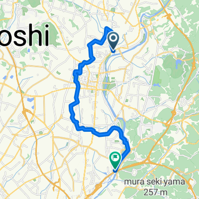
Overview
About this route
- 1 h 34 min
- Duration
- 18.5 km
- Distance
- 127 m
- Ascent
- 156 m
- Descent
- 11.8 km/h
- Avg. speed
- ---
- Max. altitude

Continue with Bikemap
Use, edit, or download this cycling route
You would like to ride Recovered Route or customize it for your own trip? Here is what you can do with this Bikemap route:
Free features
- Save this route as favorite or in collections
- Copy & plan your own version of this route
- Sync your route with Garmin or Wahoo
Premium features
Free trial for 3 days, or one-time payment. More about Bikemap Premium.
- Navigate this route on iOS & Android
- Export a GPX / KML file of this route
- Create your custom printout (try it for free)
- Download this route for offline navigation
Discover more Premium features.
Get Bikemap PremiumFrom our community
Other popular routes starting in Toyota
 Caminhada lenta Toyota-Shi
- Distance
- 16.6 km
- Ascent
- 125 m
- Descent
- 167 m
- Location
- Toyota, Aichi, Japan
 Eitakuji to Motoyama
- Distance
- 21.8 km
- Ascent
- 162 m
- Descent
- 268 m
- Location
- Toyota, Aichi, Japan
 Recovered Route
- Distance
- 18.5 km
- Ascent
- 127 m
- Descent
- 156 m
- Location
- Toyota, Aichi, Japan
 De 89-1, Heiwacho 1-Chōme, Toyota a Kamiikecho 2-Chōme, Toyota
- Distance
- 18.6 km
- Ascent
- 234 m
- Descent
- 206 m
- Location
- Toyota, Aichi, Japan
 10丁目 24, 豊田市 to 郷前, 安城市
- Distance
- 12.8 km
- Ascent
- 125 m
- Descent
- 156 m
- Location
- Toyota, Aichi, Japan
 De Minamiyama, Nisshin a 2-chōme, Nagoya
- Distance
- 9.5 km
- Ascent
- 83 m
- Descent
- 91 m
- Location
- Toyota, Aichi, Japan
 豊田安城サイクリングロード
- Distance
- 2.4 km
- Ascent
- 9 m
- Descent
- 34 m
- Location
- Toyota, Aichi, Japan
 De Kamiikecho 2-Chōme, Toyota-Shi a Kawabatacho, Toyota-Shi
- Distance
- 10.3 km
- Ascent
- 12 m
- Descent
- 39 m
- Location
- Toyota, Aichi, Japan
Open it in the app