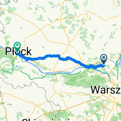
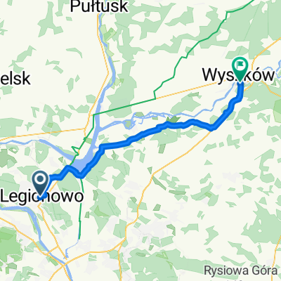
Krwawa pętla
A cycling route starting in Legionowo, Masovian Voivodeship, Poland.
Overview
About this route
Trasa rowerowa dookoła Warszawy prowadząca po szlakach pieszych. Przeczytaj więcej: https://majatravels.com/pl/krwawa-petla-terenowe-270-km-wokol-warszawy/
- -:--
- Duration
- 246.8 km
- Distance
- 882 m
- Ascent
- 884 m
- Descent
- ---
- Avg. speed
- ---
- Max. altitude
Route photos
Route quality
Waytypes & surfaces along the route
Waytypes
Track
86.4 km
(35 %)
Quiet road
51.8 km
(21 %)
Surfaces
Paved
81.4 km
(33 %)
Unpaved
81.4 km
(33 %)
Asphalt
76.5 km
(31 %)
Ground
39.5 km
(16 %)
Continue with Bikemap
Use, edit, or download this cycling route
You would like to ride Krwawa pętla or customize it for your own trip? Here is what you can do with this Bikemap route:
Free features
- Save this route as favorite or in collections
- Copy & plan your own version of this route
- Split it into stages to create a multi-day tour
- Sync your route with Garmin or Wahoo
Premium features
Free trial for 3 days, or one-time payment. More about Bikemap Premium.
- Navigate this route on iOS & Android
- Export a GPX / KML file of this route
- Create your custom printout (try it for free)
- Download this route for offline navigation
Discover more Premium features.
Get Bikemap PremiumFrom our community
Other popular routes starting in Legionowo
- Legionowo pętla 15 km
- Distance
- 14.8 km
- Ascent
- 227 m
- Descent
- 228 m
- Location
- Legionowo, Masovian Voivodeship, Poland
- Along the Wisla river (tightly)
- Distance
- 13.6 km
- Ascent
- 24 m
- Descent
- 23 m
- Location
- Legionowo, Masovian Voivodeship, Poland
- Wyszków płonie
- Distance
- 116.9 km
- Ascent
- 207 m
- Descent
- 179 m
- Location
- Legionowo, Masovian Voivodeship, Poland
- Polskiej Organizacji Wojskowej, Legionowo do Polskiej Organizacji Wojskowej, Legionowo
- Distance
- 29.1 km
- Ascent
- 22 m
- Descent
- 15 m
- Location
- Legionowo, Masovian Voivodeship, Poland
- Trasa biegowa Olszewnica Stara
- Distance
- 7.8 km
- Ascent
- 31 m
- Descent
- 31 m
- Location
- Legionowo, Masovian Voivodeship, Poland
- 2013.02.16 Historia Żydów w Radzyminie
- Distance
- 54.5 km
- Ascent
- 55 m
- Descent
- 55 m
- Location
- Legionowo, Masovian Voivodeship, Poland
- Legionowska Pętla
- Distance
- 50.7 km
- Ascent
- 39 m
- Descent
- 42 m
- Location
- Legionowo, Masovian Voivodeship, Poland
- To "Kwietniówka" lake route
- Distance
- 25.8 km
- Ascent
- 28 m
- Descent
- 26 m
- Location
- Legionowo, Masovian Voivodeship, Poland
Open it in the app