

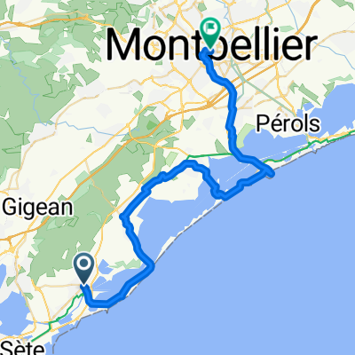
De 10 Avenue du Stade Municipal, Frontignan à Le Petit Castellas, Sète
A cycling route starting in Frontignan, Occitanie, France.
Overview
About this route
- 1 h 41 min
- Duration
- 18.4 km
- Distance
- 0 m
- Ascent
- 3 m
- Descent
- 10.9 km/h
- Avg. speed
- ---
- Max. altitude

Route quality
Waytypes & surfaces along the route
Waytypes
Cycleway
9.5 km
(52 %)
Busy road
5.8 km
(32 %)
Surfaces
Paved
16.5 km
(90 %)
Asphalt
15.4 km
(84 %)
Concrete
1.1 km
(6 %)
Continue with Bikemap
Use, edit, or download this cycling route
You would like to ride De 10 Avenue du Stade Municipal, Frontignan à Le Petit Castellas, Sète or customize it for your own trip? Here is what you can do with this Bikemap route:
Free features
- Save this route as favorite or in collections
- Copy & plan your own version of this route
- Sync your route with Garmin or Wahoo
Premium features
Free trial for 3 days, or one-time payment. More about Bikemap Premium.
- Navigate this route on iOS & Android
- Export a GPX / KML file of this route
- Create your custom printout (try it for free)
- Download this route for offline navigation
Discover more Premium features.
Get Bikemap PremiumFrom our community
Other popular routes starting in Frontignan
 Frontignan
- Distance
- 33.8 km
- Ascent
- 255 m
- Descent
- 255 m
- Location
- Frontignan, Occitanie, France
 De 10 Avenue du Stade Municipal, Frontignan à Le Petit Castellas, Sète
- Distance
- 18.4 km
- Ascent
- 0 m
- Descent
- 3 m
- Location
- Frontignan, Occitanie, France
 Frontignan-Montpellier 6. Tag, Variation 1
- Distance
- 43.3 km
- Ascent
- 103 m
- Descent
- 48 m
- Location
- Frontignan, Occitanie, France
 2019 FRONTIGNAN / CARCASSONNE
- Distance
- 148.8 km
- Ascent
- 181 m
- Descent
- 76 m
- Location
- Frontignan, Occitanie, France
 Arresquiers Sète Frontignan
- Distance
- 33.8 km
- Ascent
- 72 m
- Descent
- 95 m
- Location
- Frontignan, Occitanie, France
 Etappe alt 13 Frontignan - Gignac
- Distance
- 43.6 km
- Ascent
- 410 m
- Descent
- 361 m
- Location
- Frontignan, Occitanie, France
 3. nap
- Distance
- 112.8 km
- Ascent
- 319 m
- Descent
- 317 m
- Location
- Frontignan, Occitanie, France
 Pont du Rond-point des Étangs, Frontignan to Boulevard des Aresquiers, Vic-la-Gardiole
- Distance
- 10.7 km
- Ascent
- 22 m
- Descent
- 21 m
- Location
- Frontignan, Occitanie, France
Open it in the app