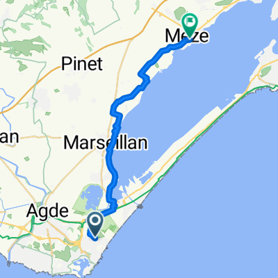
De Rond-Point du Bagnas, Agde à Rue du Gouverneur, Agde
A cycling route starting in Le Cap D'Agde, Occitanie, France.
Overview
About this route
- 11 min
- Duration
- 2.5 km
- Distance
- 0 m
- Ascent
- 3 m
- Descent
- 13.8 km/h
- Avg. speed
- ---
- Max. altitude
Continue with Bikemap
Use, edit, or download this cycling route
You would like to ride De Rond-Point du Bagnas, Agde à Rue du Gouverneur, Agde or customize it for your own trip? Here is what you can do with this Bikemap route:
Free features
- Save this route as favorite or in collections
- Copy & plan your own version of this route
- Sync your route with Garmin or Wahoo
Premium features
Free trial for 3 days, or one-time payment. More about Bikemap Premium.
- Navigate this route on iOS & Android
- Export a GPX / KML file of this route
- Create your custom printout (try it for free)
- Download this route for offline navigation
Discover more Premium features.
Get Bikemap PremiumFrom our community
Other popular routes starting in Le Cap D'Agde
- Rund um Agde
- Distance
- 28 km
- Ascent
- 63 m
- Descent
- 62 m
- Location
- Le Cap D'Agde, Occitanie, France
- safgg
- Distance
- 18.1 km
- Ascent
- 8 m
- Descent
- 4 m
- Location
- Le Cap D'Agde, Occitanie, France
- Etang de Thau
- Distance
- 78.9 km
- Ascent
- 125 m
- Descent
- 124 m
- Location
- Le Cap D'Agde, Occitanie, France
- The canals to Vias one
- Distance
- 33.3 km
- Ascent
- 47 m
- Descent
- 47 m
- Location
- Le Cap D'Agde, Occitanie, France
- agde 2
- Distance
- 7 km
- Ascent
- 16 m
- Descent
- 3 m
- Location
- Le Cap D'Agde, Occitanie, France
- Le Cap d'Agde - Toulouse
- Distance
- 197.4 km
- Ascent
- 365 m
- Descent
- 223 m
- Location
- Le Cap D'Agde, Occitanie, France
- The Meze one
- Distance
- 21 km
- Ascent
- 66 m
- Descent
- 59 m
- Location
- Le Cap D'Agde, Occitanie, France
- Beziers
- Distance
- 32.2 km
- Ascent
- 86 m
- Descent
- 26 m
- Location
- Le Cap D'Agde, Occitanie, France
Open it in the app