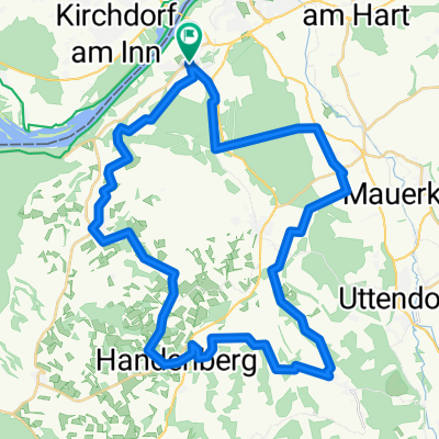
2025-W14 Eggenfelden🇩🇪
- 75.4 km
- 762 m
- 763 m
- Braunau am Inn, Upper Austria, Austria
A cycling route starting in Braunau am Inn, Upper Austria, Austria.
Overview
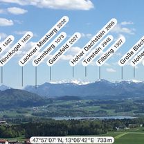
20200828_161014
Salzachstüberl https://www.oberoesterreich.at/oesterreich-gastronomie/detail/430003883/gaststaette-imbisshuette-zur-panorama-huett-n.html
created this 5 years ago

Route quality
Quiet road
15.6 km
(31 %)
Cycleway
7.1 km
(14 %)
Paved
36.3 km
(72 %)
Unpaved
1 km
(2 %)
Asphalt
35.3 km
(70 %)
Concrete
1 km
(2 %)
Route highlights
Salzachstüberl https://www.oberoesterreich.at/oesterreich-gastronomie/detail/430003883/gaststaette-imbisshuette-zur-panorama-huett-n.html
GH Putscher
Continue with Bikemap
You would like to ride 2020-W14 Ach or customize it for your own trip? Here is what you can do with this Bikemap route:
Free trial for 3 days, or one-time payment. More about Bikemap Premium.
Discover more Premium features.
Get Bikemap PremiumFrom our community
Open it in the app