

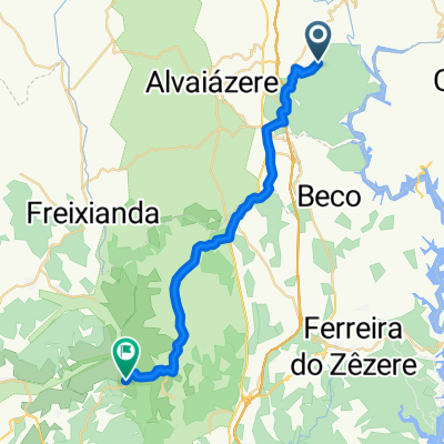
Carvalhal de São Bento/ Carvalhal de São Bento
A cycling route starting in Alvaiázere, Leiria District, Portugal.
Overview
About this route
- 2 h 4 min
- Duration
- 32.9 km
- Distance
- 463 m
- Ascent
- 442 m
- Descent
- 15.9 km/h
- Avg. speed
- ---
- Max. altitude

Route quality
Waytypes & surfaces along the route
Waytypes
Quiet road
11.8 km
(36 %)
Road
11.5 km
(35 %)
Surfaces
Paved
23.7 km
(72 %)
Asphalt
23.7 km
(72 %)
Undefined
9.2 km
(28 %)
Continue with Bikemap
Use, edit, or download this cycling route
You would like to ride Carvalhal de São Bento/ Carvalhal de São Bento or customize it for your own trip? Here is what you can do with this Bikemap route:
Free features
- Save this route as favorite or in collections
- Copy & plan your own version of this route
- Sync your route with Garmin or Wahoo
Premium features
Free trial for 3 days, or one-time payment. More about Bikemap Premium.
- Navigate this route on iOS & Android
- Export a GPX / KML file of this route
- Create your custom printout (try it for free)
- Download this route for offline navigation
Discover more Premium features.
Get Bikemap PremiumFrom our community
Other popular routes starting in Alvaiázere
 De Rua das Alminhas a Rua da Bacelada
- Distance
- 44 km
- Ascent
- 286 m
- Descent
- 291 m
- Location
- Alvaiázere, Leiria District, Portugal
 1807ii Alvalazere Coimbra
- Distance
- 53.5 km
- Ascent
- 491 m
- Descent
- 779 m
- Location
- Alvaiázere, Leiria District, Portugal
 agroal
- Distance
- 27.3 km
- Ascent
- 337 m
- Descent
- 674 m
- Location
- Alvaiázere, Leiria District, Portugal
 Murta to Dornes
- Distance
- 9.6 km
- Ascent
- 161 m
- Descent
- 274 m
- Location
- Alvaiázere, Leiria District, Portugal
 Alvaiazere, Portugal - Tomar, Portugal
- Distance
- 31.8 km
- Ascent
- 153 m
- Descent
- 392 m
- Location
- Alvaiázere, Leiria District, Portugal
 Portugal Etapa04 Alvaiaere Coimbra
- Distance
- 63.4 km
- Ascent
- 597 m
- Descent
- 843 m
- Location
- Alvaiázere, Leiria District, Portugal
 Rua N.ª Sr.ª da Piedade 19, Alvaiázere to Rua Adelino da Veiga 74, Coimbra
- Distance
- 68.6 km
- Ascent
- 1,128 m
- Descent
- 1,417 m
- Location
- Alvaiázere, Leiria District, Portugal
 4d Alvaiazere - Tomar - Fatima - Batalha 70km 680m sukilimo
- Distance
- 69.7 km
- Ascent
- 596 m
- Descent
- 719 m
- Location
- Alvaiázere, Leiria District, Portugal
Open it in the app