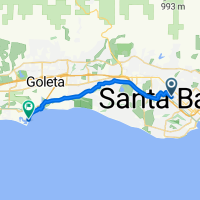
28–46 E Gutierrez St, Santa Barbara to 2981 Cliff Dr, Santa Barbara
A cycling route starting in Santa Barbara, California, United States of America.
Overview
About this route
- 31 min
- Duration
- 6.8 km
- Distance
- 0 m
- Ascent
- 6 m
- Descent
- 13.3 km/h
- Avg. speed
- ---
- Avg. speed
Route quality
Waytypes & surfaces along the route
Waytypes
Quiet road
3.1 km
(46 %)
Access road
1.5 km
(22 %)
Surfaces
Paved
1 km
(15 %)
Asphalt
0.9 km
(14 %)
Paved (undefined)
0.1 km
(1 %)
Undefined
5.8 km
(85 %)
Continue with Bikemap
Use, edit, or download this cycling route
You would like to ride 28–46 E Gutierrez St, Santa Barbara to 2981 Cliff Dr, Santa Barbara or customize it for your own trip? Here is what you can do with this Bikemap route:
Free features
- Save this route as favorite or in collections
- Copy & plan your own version of this route
- Sync your route with Garmin or Wahoo
Premium features
Free trial for 3 days, or one-time payment. More about Bikemap Premium.
- Navigate this route on iOS & Android
- Export a GPX / KML file of this route
- Create your custom printout (try it for free)
- Download this route for offline navigation
Discover more Premium features.
Get Bikemap PremiumFrom our community
Other popular routes starting in Santa Barbara
- CDT2010 Day 6
- Distance
- 140 km
- Ascent
- 261 m
- Descent
- 252 m
- Location
- Santa Barbara, California, United States of America
- Montecito Loop: Park Ln, Bella Vista, Viola, Toro, Coast
- Distance
- 35.2 km
- Ascent
- 514 m
- Descent
- 514 m
- Location
- Santa Barbara, California, United States of America
- Coronel Place 525, Santa Barbara to Coronel Place 524, Santa Barbara
- Distance
- 45.7 km
- Ascent
- 1,898 m
- Descent
- 1,642 m
- Location
- Santa Barbara, California, United States of America
- sb to los olivos
- Distance
- 58.6 km
- Ascent
- 982 m
- Descent
- 747 m
- Location
- Santa Barbara, California, United States of America
- Aufnahme vom 11.05.2016, 18:14
- Distance
- 22.8 km
- Ascent
- 390 m
- Descent
- 385 m
- Location
- Santa Barbara, California, United States of America
- Santa Barbara Triathlon - Long Course 2011
- Distance
- 56.4 km
- Ascent
- 432 m
- Descent
- 435 m
- Location
- Santa Barbara, California, United States of America
- SBA2LAX Rail + Bike ride
- Distance
- 170.8 km
- Ascent
- 334 m
- Descent
- 250 m
- Location
- Santa Barbara, California, United States of America
- Santa Barbara Mountain Drive Ride
- Distance
- 41 km
- Ascent
- 585 m
- Descent
- 585 m
- Location
- Santa Barbara, California, United States of America
Open it in the app