

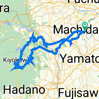
enoshima Beach route
A cycling route starting in Machida, Tokyo, Japan.
Overview
About this route
- -:--
- Duration
- 29.2 km
- Distance
- 281 m
- Ascent
- 333 m
- Descent
- ---
- Avg. speed
- ---
- Max. altitude

Route quality
Waytypes & surfaces along the route
Waytypes
Road
14 km
(48 %)
Quiet road
8.5 km
(29 %)
Surfaces
Paved
17.8 km
(61 %)
Asphalt
15.8 km
(54 %)
Paved (undefined)
2 km
(7 %)
Undefined
11.4 km
(39 %)
Continue with Bikemap
Use, edit, or download this cycling route
You would like to ride enoshima Beach route or customize it for your own trip? Here is what you can do with this Bikemap route:
Free features
- Save this route as favorite or in collections
- Copy & plan your own version of this route
- Sync your route with Garmin or Wahoo
Premium features
Free trial for 3 days, or one-time payment. More about Bikemap Premium.
- Navigate this route on iOS & Android
- Export a GPX / KML file of this route
- Create your custom printout (try it for free)
- Download this route for offline navigation
Discover more Premium features.
Get Bikemap PremiumFrom our community
Other popular routes starting in Machida
 初ライド
初ライド- Distance
- 36.7 km
- Ascent
- 108 m
- Descent
- 106 m
- Location
- Machida, Tokyo, Japan
 Route from 2-chōme 41, Machida
- Distance
- 14.8 km
- Ascent
- 175 m
- Descent
- 207 m
- Location
- Machida, Tokyo, Japan
 家から橋本コーナンまで
- Distance
- 8.8 km
- Ascent
- 95 m
- Descent
- 65 m
- Location
- Machida, Tokyo, Japan
 試しルート
試しルート- Distance
- 657.1 km
- Ascent
- 5,370 m
- Descent
- 5,422 m
- Location
- Machida, Tokyo, Japan
 Monomi-Dirt
- Distance
- 103.4 km
- Ascent
- 3,002 m
- Descent
- 3,002 m
- Location
- Machida, Tokyo, Japan
 enoshima Beach route
- Distance
- 29.2 km
- Ascent
- 281 m
- Descent
- 333 m
- Location
- Machida, Tokyo, Japan
 Giro semplice in Minami-Ku, Sagamihara-Shi
- Distance
- 72.1 km
- Ascent
- 252 m
- Descent
- 278 m
- Location
- Machida, Tokyo, Japan
 navy road
- Distance
- 18.7 km
- Ascent
- 83 m
- Descent
- 80 m
- Location
- Machida, Tokyo, Japan
Open it in the app