

ayagaures-tederas
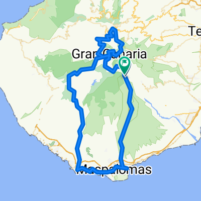
A cycling route starting in San Bartolomé de Tirajana, Canary Islands, Spain.
Overview
About this route
0
Short but very steep route. Very beautiful scenery.
- -:--
- Duration
- 7.3 km
- Distance
- 532 m
- Ascent
- 206 m
- Descent
- ---
- Avg. speed
- ---
- Max. altitude
ALópez
created this 15 years ago
Route quality
Waytypes & surfaces along the route
Waytypes
Track
5.5 km
75 %
Path
1.1 km
15 %
Quiet road
0.7 km
10 %
Surfaces
Paved
0.3 km
(4 %)
Unpaved
5.4 km
(73 %)
Gravel
5.1 km
70 %
Ground
0.2 km
3 %
Continue with Bikemap
Use, edit, or download this cycling route
You would like to ride ayagaures-tederas or customize it for your own trip? Here is what you can do with this Bikemap route:
Free features
- Save this route as favorite or in collections
- Copy & plan your own version of this route
- Sync your route with Garmin or Wahoo
Premium features
Free trial for 3 days, or one-time payment. More about Bikemap Premium.
- Navigate this route on iOS & Android
- Export a GPX / KML file of this route
- Create your custom printout (try it for free)
- Download this route for offline navigation
Discover more Premium features.
Get Bikemap PremiumFrom our community
Other popular routes starting in San Bartolomé de Tirajana
- San Bartolomé de Tirajana - Maspalomas0
- 25.8 km
- 0 m
- 0 m
- San Bartolomé de Tirajana, Canary Islands, Spain
- San Bartolome around Pico de las Nieves0
- 53.2 km
- 1,286 m
- 1,287 m
- San Bartolomé de Tirajana, Canary Islands, Spain
- Pico Pozo Las Nieves - Muelle Deportivo2
- 47.1 km
- 354 m
- 2,268 m
- San Bartolomé de Tirajana, Canary Islands, Spain


Open it in the app