

Stari Grad - Vidikovac - sv. Nikola - Dol - Stari Grad
A cycling route starting in Stari Grad, Split-Dalmatia County, Croatia.
Overview
About this route
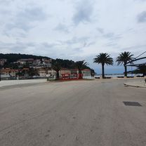
A circular track, a combination of tarmac and unpaved road, 21,5km long. Located on the centre area of the island the track begins in Stari Grad on the corner of city park. Continuing west we reach the ferry port, where we turn in the old road towards Velo Grablje. Just before the viewpoint, the path turns east to the unpaved road, climbing up to the highest point of Hvar, St. Nicholas (Sv. Nikola, 626m). After a short break and a nice view from the peak, the path descends towards Dol village in the south, continuing through the Starigrad field, ending in Stari Grad.
- -:--
- Duration
- 21.2 km
- Distance
- 575 m
- Ascent
- 575 m
- Descent
- ---
- Avg. speed
- ---
- Max. altitude

Route quality
Waytypes & surfaces along the route
Waytypes
Track
11.7 km
(55 %)
Busy road
5.3 km
(25 %)
Surfaces
Paved
9 km
(42 %)
Unpaved
5.7 km
(27 %)
Paved (undefined)
6 km
(28 %)
Gravel
5.7 km
(27 %)
Continue with Bikemap
Use, edit, or download this cycling route
You would like to ride Stari Grad - Vidikovac - sv. Nikola - Dol - Stari Grad or customize it for your own trip? Here is what you can do with this Bikemap route:
Free features
- Save this route as favorite or in collections
- Copy & plan your own version of this route
- Sync your route with Garmin or Wahoo
Premium features
Free trial for 3 days, or one-time payment. More about Bikemap Premium.
- Navigate this route on iOS & Android
- Export a GPX / KML file of this route
- Create your custom printout (try it for free)
- Download this route for offline navigation
Discover more Premium features.
Get Bikemap PremiumFrom our community
Other popular routes starting in Stari Grad
 stari grad - Medjugorje 3 tappa
- Distance
- 130.5 km
- Ascent
- 1,040 m
- Descent
- 874 m
- Location
- Stari Grad, Split-Dalmatia County, Croatia
 Starigrad - Jelsa - Vrbovska (krožna)
- Distance
- 21.9 km
- Ascent
- 210 m
- Descent
- 210 m
- Location
- Stari Grad, Split-Dalmatia County, Croatia
 Stari Grad - Jelsa
- Distance
- 13.9 km
- Ascent
- 229 m
- Descent
- 232 m
- Location
- Stari Grad, Split-Dalmatia County, Croatia
 Stari Grad - Vrbanj - Jelsa - Vrboska - Stari Grad
- Distance
- 19.6 km
- Ascent
- 156 m
- Descent
- 154 m
- Location
- Stari Grad, Split-Dalmatia County, Croatia
 pętla hvar 2
- Distance
- 45.7 km
- Ascent
- 1,080 m
- Descent
- 1,081 m
- Location
- Stari Grad, Split-Dalmatia County, Croatia
 Hvar
Hvar- Distance
- 46.5 km
- Ascent
- 1,149 m
- Descent
- 1,144 m
- Location
- Stari Grad, Split-Dalmatia County, Croatia
 Sv. Nikolaj
- Distance
- 12.2 km
- Ascent
- 479 m
- Descent
- 479 m
- Location
- Stari Grad, Split-Dalmatia County, Croatia
 Hvar - Zavala
- Distance
- 49.6 km
- Ascent
- 751 m
- Descent
- 680 m
- Location
- Stari Grad, Split-Dalmatia County, Croatia
Open it in the app