

stm-międz-anin-mar-wesł
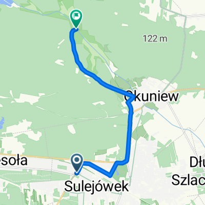
A cycling route starting in Sulejówek, Masovian Voivodeship, Poland.
Overview
About this route
- 1 h 6 min
- Duration
- 19.1 km
- Distance
- 775 m
- Ascent
- 751 m
- Descent
- 17.4 km/h
- Avg. speed
- ---
- Max. altitude

Continue with Bikemap
Use, edit, or download this cycling route
You would like to ride stm-międz-anin-mar-wesł or customize it for your own trip? Here is what you can do with this Bikemap route:
Free features
- Save this route as favorite or in collections
- Copy & plan your own version of this route
- Sync your route with Garmin or Wahoo
Premium features
Free trial for 3 days, or one-time payment. More about Bikemap Premium.
- Navigate this route on iOS & Android
- Export a GPX / KML file of this route
- Create your custom printout (try it for free)
- Download this route for offline navigation
Discover more Premium features.
Get Bikemap PremiumFrom our community
Other popular routes starting in Sulejówek
 Iron Loop
- Distance
- 65.2 km
- Ascent
- 47 m
- Descent
- 47 m
- Location
- Sulejówek, Masovian Voivodeship, Poland
 PRMS D4
- Distance
- 24.4 km
- Ascent
- 53 m
- Descent
- 64 m
- Location
- Sulejówek, Masovian Voivodeship, Poland
 trasa historyczna
- Distance
- 18.9 km
- Ascent
- 26 m
- Descent
- 23 m
- Location
- Sulejówek, Masovian Voivodeship, Poland
 Sulejówek - Mosty for Kids
- Distance
- 8.6 km
- Ascent
- 22 m
- Descent
- 27 m
- Location
- Sulejówek, Masovian Voivodeship, Poland
 Kępa Wieloryb+widok na Wisłę
- Distance
- 37.8 km
- Ascent
- 204 m
- Descent
- 219 m
- Location
- Sulejówek, Masovian Voivodeship, Poland
 Góry Chobockie
- Distance
- 36.7 km
- Ascent
- 449 m
- Descent
- 445 m
- Location
- Sulejówek, Masovian Voivodeship, Poland
 Warszawa Póludniowy Wschód
- Distance
- 52.1 km
- Ascent
- 53 m
- Descent
- 54 m
- Location
- Sulejówek, Masovian Voivodeship, Poland
 Skarpa
- Distance
- 40.1 km
- Ascent
- 342 m
- Descent
- 348 m
- Location
- Sulejówek, Masovian Voivodeship, Poland
Open it in the app