

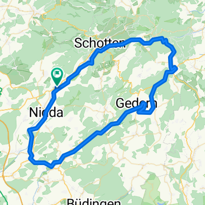
Hoherrodskopfsteig - Vulkanradweg - R4
A cycling route starting in Nidda, Hesse, Germany.
Overview
About this route
Best route from Hoherrodskopf to Herchenhainer Höhe!!!
- -:--
- Duration
- 75.4 km
- Distance
- 730 m
- Ascent
- 730 m
- Descent
- ---
- Avg. speed
- ---
- Max. altitude
Route quality
Waytypes & surfaces along the route
Waytypes
Track
33.9 km
(45 %)
Cycleway
18.1 km
(24 %)
Surfaces
Paved
61.8 km
(82 %)
Unpaved
9.8 km
(13 %)
Asphalt
59.5 km
(79 %)
Gravel
7.5 km
(10 %)
Continue with Bikemap
Use, edit, or download this cycling route
You would like to ride Hoherrodskopfsteig - Vulkanradweg - R4 or customize it for your own trip? Here is what you can do with this Bikemap route:
Free features
- Save this route as favorite or in collections
- Copy & plan your own version of this route
- Sync your route with Garmin or Wahoo
Premium features
Free trial for 3 days, or one-time payment. More about Bikemap Premium.
- Navigate this route on iOS & Android
- Export a GPX / KML file of this route
- Create your custom printout (try it for free)
- Download this route for offline navigation
Discover more Premium features.
Get Bikemap PremiumFrom our community
Other popular routes starting in Nidda
 Hoherrodskopfsteig - Vulkanradweg - R4
- Distance
- 75.4 km
- Ascent
- 730 m
- Descent
- 730 m
- Location
- Nidda, Hesse, Germany
 2019 07 09 Nidda - Hoherodskopf - Wächtersbach
- Distance
- 67.6 km
- Ascent
- 691 m
- Descent
- 679 m
- Location
- Nidda, Hesse, Germany
 Mammutbäume Niddastausee
- Distance
- 40.1 km
- Ascent
- 427 m
- Descent
- 413 m
- Location
- Nidda, Hesse, Germany
 DM Jedermann 2017
- Distance
- 17.4 km
- Ascent
- 286 m
- Descent
- 288 m
- Location
- Nidda, Hesse, Germany
 Rote Brücke - alte Schottener Strasse
- Distance
- 41.4 km
- Ascent
- 280 m
- Descent
- 280 m
- Location
- Nidda, Hesse, Germany
 Kloster Lich
- Distance
- 51.7 km
- Ascent
- 151 m
- Descent
- 148 m
- Location
- Nidda, Hesse, Germany
 rundfahrt11.4.2020
- Distance
- 61 km
- Ascent
- 653 m
- Descent
- 660 m
- Location
- Nidda, Hesse, Germany
 K195 38, Nidda nach Gäßchen 23, Nidda
- Distance
- 33.9 km
- Ascent
- 958 m
- Descent
- 909 m
- Location
- Nidda, Hesse, Germany
Open it in the app