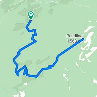
Bike&Hike: Trainsjochrunde mit Trail
A cycling route starting in Langkampfen, Tyrol, Austria.
Overview
About this route
Von Wieshäusl zur Trainsalm, kurz oberhalb der hütte kurze schiebestrecke bis zur abzweigung zum trinsjoch. Radl stehen lassen und kurzer weg rauf zum Gipfelkreuz. den selben weg zurück zum Fahhrad. jetzt kurzer leichter Trail zur Trockenbachalm. jetzt entweder Forststrasse runter oder nochmal einen leichten Trail. Runter zur UrsprungStaße. Von dort einfach der Aspaltstraße zum Ausgangspunkt zurückrollen.
- -:--
- Duration
- 22.5 km
- Distance
- 1,103 m
- Ascent
- 1,098 m
- Descent
- ---
- Avg. speed
- ---
- Avg. speed
Continue with Bikemap
Use, edit, or download this cycling route
You would like to ride Bike&Hike: Trainsjochrunde mit Trail or customize it for your own trip? Here is what you can do with this Bikemap route:
Free features
- Save this route as favorite or in collections
- Copy & plan your own version of this route
- Sync your route with Garmin or Wahoo
Premium features
Free trial for 3 days, or one-time payment. More about Bikemap Premium.
- Navigate this route on iOS & Android
- Export a GPX / KML file of this route
- Create your custom printout (try it for free)
- Download this route for offline navigation
Discover more Premium features.
Get Bikemap PremiumFrom our community
Other popular routes starting in Langkampfen
- Langkampfen - Hohe Salve - Angath
- Distance
- 43.3 km
- Ascent
- 1,369 m
- Descent
- 1,410 m
- Location
- Langkampfen, Tyrol, Austria
- Schneeberg-Pendling
- Distance
- 5.8 km
- Ascent
- 745 m
- Descent
- 206 m
- Location
- Langkampfen, Tyrol, Austria
- Pendling Runde CLONED FROM ROUTE 185370
- Distance
- 18.6 km
- Ascent
- 658 m
- Descent
- 722 m
- Location
- Langkampfen, Tyrol, Austria
- Hohe Salve Itter Trail
- Distance
- 43.3 km
- Ascent
- 1,367 m
- Descent
- 1,406 m
- Location
- Langkampfen, Tyrol, Austria
- Um das hintere Sonnwendjoch
- Distance
- 46.5 km
- Ascent
- 1,469 m
- Descent
- 1,471 m
- Location
- Langkampfen, Tyrol, Austria
- Bike&Hike: Trainsjochrunde mit Trail
- Distance
- 22.5 km
- Ascent
- 1,103 m
- Descent
- 1,098 m
- Location
- Langkampfen, Tyrol, Austria
- Tirolo 1
- Distance
- 59.8 km
- Ascent
- 1,010 m
- Descent
- 1,005 m
- Location
- Langkampfen, Tyrol, Austria
- Hinterthierseer Panoramarunde
- Distance
- 30.1 km
- Ascent
- 1,009 m
- Descent
- 1,014 m
- Location
- Langkampfen, Tyrol, Austria
Open it in the app