

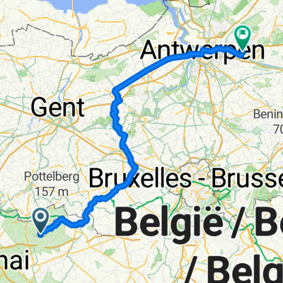
Overview
About this route
- -:--
- Duration
- 66.4 km
- Distance
- 666 m
- Ascent
- 666 m
- Descent
- ---
- Avg. speed
- ---
- Max. altitude

Part of
Walonië
2 stages
Route quality
Waytypes & surfaces along the route
Waytypes
Quiet road
41.8 km
(63 %)
Road
22.6 km
(34 %)
Surfaces
Paved
27.2 km
(41 %)
Asphalt
23.9 km
(36 %)
Concrete
3.3 km
(5 %)
Undefined
39.2 km
(59 %)
Route highlights
Points of interest along the route
Point of interest after 27.4 km
onverhard (heel slecht)
Point of interest after 27.4 km
onverhard (goed)
Point of interest after 31.3 km
au chaudron des légendes
Point of interest after 34.2 km
trap!!!!!!!!!!!!!!!!!!!
Point of interest after 46.7 km
onverhard
Point of interest after 57.4 km
kasteel
Continue with Bikemap
Use, edit, or download this cycling route
You would like to ride saint-sauveur2 - 66.4 or customize it for your own trip? Here is what you can do with this Bikemap route:
Free features
- Save this route as favorite or in collections
- Copy & plan your own version of this route
- Sync your route with Garmin or Wahoo
Premium features
Free trial for 3 days, or one-time payment. More about Bikemap Premium.
- Navigate this route on iOS & Android
- Export a GPX / KML file of this route
- Create your custom printout (try it for free)
- Download this route for offline navigation
Discover more Premium features.
Get Bikemap PremiumFrom our community
Other popular routes starting in Frasnes-lez-Anvaing
 Saint Sauveur
- Distance
- 20.7 km
- Ascent
- 339 m
- Descent
- 341 m
- Location
- Frasnes-lez-Anvaing, Wallonia, Belgium
 ZO 31/05
- Distance
- 22.5 km
- Ascent
- 119 m
- Descent
- 119 m
- Location
- Frasnes-lez-Anvaing, Wallonia, Belgium
 saint-sauveur2 - 66.4
- Distance
- 66.4 km
- Ascent
- 666 m
- Descent
- 666 m
- Location
- Frasnes-lez-Anvaing, Wallonia, Belgium
 saint-sauveur1 - 57.7
- Distance
- 57.7 km
- Ascent
- 561 m
- Descent
- 561 m
- Location
- Frasnes-lez-Anvaing, Wallonia, Belgium
 saint-sauveur4 - 60.7
- Distance
- 60.7 km
- Ascent
- 453 m
- Descent
- 453 m
- Location
- Frasnes-lez-Anvaing, Wallonia, Belgium
 De Rue Beausoir 15, Frasnes-lez-Anvaing à Rue Beausoir 15, Frasnes-lez-Anvaing
- Distance
- 12.4 km
- Ascent
- 306 m
- Descent
- 306 m
- Location
- Frasnes-lez-Anvaing, Wallonia, Belgium
 From Frasnes-lez-Anvaing to Schilde
- Distance
- 136.6 km
- Ascent
- 286 m
- Descent
- 348 m
- Location
- Frasnes-lez-Anvaing, Wallonia, Belgium
 Outrijve - Helkijn - Celles - Anvaing - thuis
- Distance
- 40.4 km
- Ascent
- 175 m
- Descent
- 173 m
- Location
- Frasnes-lez-Anvaing, Wallonia, Belgium
Open it in the app