
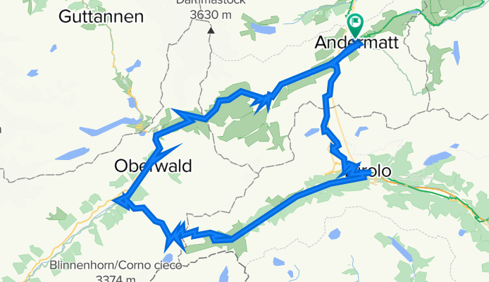
Furka-Nufenen-Gotthard (Tremola): The classic passes of central Switzerland
A cycling route starting in Andermatt, Canton of Uri, Switzerland.
Overview
About this route
Three legendary passes that regularly feature on the Tour de Suisse programme, the Furka-Nufenen-Gothard loop is an Alpine classic for cycling enthusiasts. It is only 106 kilometres long, but it should not be underestimated: with almost 40 kilometres of ascent, climbing is a big chunk of the ride.
- -:--
- Duration
- 101 km
- Distance
- 3,539 m
- Ascent
- 3,540 m
- Descent
- ---
- Avg. speed
- ---
- Avg. speed

Route quality
Waytypes & surfaces along the route
Waytypes
Busy road
91.3 km
(90 %)
Quiet road
5.2 km
(5 %)
Surfaces
Paved
89.2 km
(88 %)
Unpaved
0.9 km
(<1 %)
Asphalt
87.2 km
(86 %)
Concrete
1.2 km
(1 %)
Continue with Bikemap
Use, edit, or download this cycling route
You would like to ride Furka-Nufenen-Gotthard (Tremola): The classic passes of central Switzerland or customize it for your own trip? Here is what you can do with this Bikemap route:
Free features
- Save this route as favorite or in collections
- Copy & plan your own version of this route
- Split it into stages to create a multi-day tour
- Sync your route with Garmin or Wahoo
Premium features
Free trial for 3 days, or one-time payment. More about Bikemap Premium.
- Navigate this route on iOS & Android
- Export a GPX / KML file of this route
- Create your custom printout (try it for free)
- Download this route for offline navigation
Discover more Premium features.
Get Bikemap PremiumFrom our community
Other popular routes starting in Andermatt
 Transalpine (7) Andermatt - Visp
- Distance
- 89.5 km
- Ascent
- 1,685 m
- Descent
- 2,290 m
- Location
- Andermatt, Canton of Uri, Switzerland
 20.09.2010 Furka, Nufenen, Gotthard
- Distance
- 98.5 km
- Ascent
- 2,959 m
- Descent
- 2,959 m
- Location
- Andermatt, Canton of Uri, Switzerland
 NL The Rhine Cycle Route
- Distance
- 1,352.1 km
- Ascent
- 88 m
- Descent
- 1,523 m
- Location
- Andermatt, Canton of Uri, Switzerland
 VR01 Furkapass Belvedere-Brig.kml - VR01 Furkapass Belvedere-Brig.kml_VR01 Furkapass Belvedere-Brig
- Distance
- 60.1 km
- Ascent
- 852 m
- Descent
- 2,409 m
- Location
- Andermatt, Canton of Uri, Switzerland
![[DAY 19] Göschenen - Ilanz](https://media.bikemap.net/routes/8561780/gallery/thumbs/af10c4bc-a85d-4013-8c11-c6c25ccc528a.jpeg.208x208_q80_crop.jpg) [DAY 19] Göschenen - Ilanz
[DAY 19] Göschenen - Ilanz- Distance
- 68.1 km
- Ascent
- 984 m
- Descent
- 1,380 m
- Location
- Andermatt, Canton of Uri, Switzerland
 Rheinradweg
- Distance
- 1,085.7 km
- Ascent
- 107 m
- Descent
- 1,544 m
- Location
- Andermatt, Canton of Uri, Switzerland
 Witenwasseren Bike
- Distance
- 17.3 km
- Ascent
- 808 m
- Descent
- 26 m
- Location
- Andermatt, Canton of Uri, Switzerland
 Rhine Cycle Route - Switzerland
- Distance
- 492.2 km
- Ascent
- 6,424 m
- Descent
- 7,590 m
- Location
- Andermatt, Canton of Uri, Switzerland
Open it in the app