

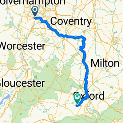
40km - Sunday ride
A cycling route starting in Halesowen, England, United Kingdom.
Overview
About this route
- -:--
- Duration
- 38.7 km
- Distance
- 210 m
- Ascent
- 210 m
- Descent
- ---
- Avg. speed
- ---
- Max. altitude

Route quality
Waytypes & surfaces along the route
Waytypes
Cycleway
24.4 km
(63 %)
Road
4.4 km
(11 %)
Surfaces
Paved
14.2 km
(37 %)
Asphalt
9.2 km
(24 %)
Paved (undefined)
3.6 km
(9 %)
Continue with Bikemap
Use, edit, or download this cycling route
You would like to ride 40km - Sunday ride or customize it for your own trip? Here is what you can do with this Bikemap route:
Free features
- Save this route as favorite or in collections
- Copy & plan your own version of this route
- Sync your route with Garmin or Wahoo
Premium features
Free trial for 3 days, or one-time payment. More about Bikemap Premium.
- Navigate this route on iOS & Android
- Export a GPX / KML file of this route
- Create your custom printout (try it for free)
- Download this route for offline navigation
Discover more Premium features.
Get Bikemap PremiumFrom our community
Other popular routes starting in Halesowen
 23 Lydate Road, Birmingham to 67 King Charles Road, Birmingham
- Distance
- 6.4 km
- Ascent
- 53 m
- Descent
- 52 m
- Location
- Halesowen, England, United Kingdom
 Club run
- Distance
- 39.4 km
- Ascent
- 415 m
- Descent
- 415 m
- Location
- Halesowen, England, United Kingdom
 40km - Sunday ride
- Distance
- 38.7 km
- Ascent
- 210 m
- Descent
- 210 m
- Location
- Halesowen, England, United Kingdom
 2 Foxlea Road, Halesowen to 2 Foxlea Road, Halesowen
- Distance
- 9.2 km
- Ascent
- 112 m
- Descent
- 113 m
- Location
- Halesowen, England, United Kingdom
 Route to Blandy Avenue 29, Southmoor
- Distance
- 160.9 km
- Ascent
- 124 m
- Descent
- 228 m
- Location
- Halesowen, England, United Kingdom
 03/09/2020 Ride
- Distance
- 18 km
- Ascent
- 167 m
- Descent
- 164 m
- Location
- Halesowen, England, United Kingdom
 Recovered Route
- Distance
- 3.1 km
- Ascent
- 9 m
- Descent
- 51 m
- Location
- Halesowen, England, United Kingdom
 Road Ride around base of Clent
- Distance
- 17.5 km
- Ascent
- 299 m
- Descent
- 309 m
- Location
- Halesowen, England, United Kingdom
Open it in the app