018 - 2014
- 77.7 km
- 1,637 m
- 2,039 m
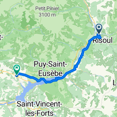
- Guillestre, Provence-Alpes-Côte d'Azur Region, France
A cycling route starting in Guillestre, Provence-Alpes-Côte d'Azur Region, France.
Overview
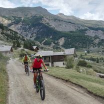
From the shop, return to Saint Guillaume and take the first right. Continue to the footbridge. Cross there, then climb up to the departmental road. Travel about 200m in the direction of Gap and take the camping road on your right just after the bridge. You will enjoy a specially laid out path for you. Take the path that climbs quite steeply on your right after the small bridge. Follow this trail to the village of Risoul where you will rejoin the departmental road. Then follow the departmental road to the town hall junction. Climb to the left of the town hall (direction Collet). Take the forest track (old Risoul road) that goes up to the station. Reach the Tourist Office. Follow the direction to Lake Pré du Laus which leads west at the top of the station. This pleasant road rises through the larch forest then reaches Lake Pré du Laus and descends slightly to the shelter located between the ridges of Martinat and the Penon ridge. A magnificent view then opens up with the Durance valley, the Embrunais and Lake Serre-Ponçon! Take the path after the shelter which follows the Penon ridge then dives into the forest. After some hairpins, you reach a logging track that you must follow down. The path narrows again and turns left. This nice easy descent through the larch forest arrives above the hamlet of Barbein. Just before the houses, take left the Plan de Phasy path. The route ends above the Rotunda and the hot springs. From there, return towards Guillestre via a balcony trail above the road that heads to "Les Isclasses". Once you reach the road, take it downhill to access "Les Isclasses" and then the industrial area of "Le Villard". Climb there passing the Fromagerie de la Durance in order to find the National road. Climb about 200m then turn right at "Gaboyer". Then return by the same route to Saint Guillaume. From there, take the second left where you can finish your ride on the embankment along the Guil. A small path hides on the right to reach the shop. You have arrived!
CULTURAL: Risoul 1850 station
PEDAGOGICAL: Long climb, know how to manage your effort.
SOCIAL
created this 5 years ago
Route quality
Track
10.8 km
(41 %)
Quiet road
6.3 km
(24 %)
Paved
5.8 km
(22 %)
Unpaved
10.5 km
(40 %)
Gravel
8.4 km
(32 %)
Asphalt
5.8 km
(22 %)
Route highlights

La Remise de Sophie
Patrimoine rural: Pierre verte (1126 m) Du 11ème au 19ème, Guillestre et Risoul sont très proches, ce qui nécessite des précautions pour la gestion du patrimoine commun. La charte de 1329 prescrit l'élection commune des premiers consuls, dépositaires de l'autorité. L'élection est faite par les chefs de famille. Selon la tradition locale, la rencontre entre les consuls se faisait à la \"pierre verte\", à la limite des communes de Risoul et Guillestre. La révolution française bouleversera ce mode d'organisation administratif local en harmonisant le même fonctionnement pour toute la France. Escartons, charte et autres organisations locales disparaîtront. Vérité historique ou légende ? La pierre verte symbolise une pratique originale de la démocratie locale, et les liens que les habitants de Risoul avaient avec Guillestre.. Site visible en extérieur. Lat/Lon : 44.64816/6.63932

La Ferme de Chagne

Swim café

La Station de ski Risoul 1850 est créée en 1971 sur les hauteurs de Risoul. La piste la plus haute se trouvant à 2457 mètres d'altitude. Aujourd'hui, la station accueille les skieurs en hiver et l'été, les pistes se transforment en alpages où bovins et ovins remplacent les sportifs ! Pour les activités en station, se renseigner auprès de l'office de tourisme de Risoul.

Le Lac du Pré du Laus
Anciens fours à Chaux

GUIL eBIKE
Continue with Bikemap
You would like to ride N°21:La Crête du Penon or customize it for your own trip? Here is what you can do with this Bikemap route:
Free trial for 3 days, or one-time payment. More about Bikemap Premium.
Discover more Premium features.
Get Bikemap PremiumFrom our community
Open it in the app